Guadalupe Victoria geodata
Guadalupe Victoria (Guerrero) is a populated place; located in Mexico in America/Mexico_City (GMT-6) time zone. With population of 537 people, there are 15796 cities with bigger population in this country. Compared to other cities in Mexico, 78.9% of cities are located further ↑North; 58.8% of cities are located further ←West and 50.5% of cities have higher elevation than Guadalupe Victoria. Note1


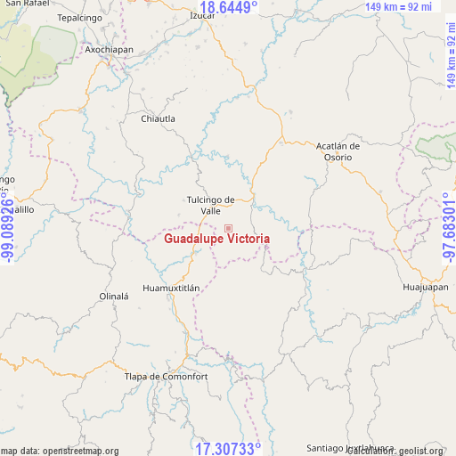
Guadalupe Victoria GPS coordinates[2]
17° 58' 38.568" North, 98° 23' 10.068" West
| Map corner | latitude | longitude |
|---|---|---|
| Upper-left | 18.6449°, | -99.08926° |
| Center: | 17.97738°, | -98.38613° |
| Lower-right: | 17.30733°, | -97.68301° |
| Map W x H: | 148.7×148.7 km | = 92.4×92.4mi |
| max Lat: | 32.7° ⇑78.9% North |
| Guadalupe Victoria: | 17.97738° |
| min Lat: | ⇓21.1% South 14.53588° |
| min Long | Guadalupe Victo | max Long |
| -117.105° | -98.38613° | -86.73105° |
| W 58.8%⇐ | ⇒41.2% E |
Elevation
Elevation of Guadalupe Victoria is 1407 m = 4616 ft, and this is 153.3 m = 503 ft above average elevation for this country.
| Max E: |
3497 m = 11473 ft | 50.5% |
| Guadalupe Victoria | 1407 m 4616 ft | |
| Avg. | 1253.7 m = 4113 ft | |
Min E: |
-1 m = -3 ft | 49.5% |
See also: Mexico elevation on elevation.city.
Geographical zone
Guadalupe Victoria is located in North Torrid zone (between Equator and Tropic of Cancer). Distance of this Northern Tropic circle is 607 km =377.2 mi to North.| Distance of | km | miles | from Guadalupe Victoria |
|---|---|---|---|
| North Pole | 8008.2 | 4976.1 | to North |
| Arctic Circle | 5402.3 | 3356.8 | to North |
| Tropic Cancer | 607 | 377.2 | to North |
| Equator | 1998.9 | 1242.1 | to South |


Nearby cities:
15 places around Guadalupe Victoria: (largest is in red/bold)
• Acaxtlahuacán de Albino Zertuche
16.9 km =10.5 mi,  285°
285°
• Chila de la Sal
18.1 km =11.2 mi,  324°
324°
• Guadalupe del Recreo
20.5 km =12.7 mi,  164°
164°
• Ilamacingo
15.8 km =9.8 mi,  77°
77°
• Olomatlán
12.8 km =8 mi,  105°
105°
• Progreso
10.4 km =6.5 mi,  49°
49°
• San Juan la Ciénega
18 km =11.2 mi,  141°
141°
• San Miguel Comitlipa
17.6 km =10.9 mi,  265°
265°
• San Miguel Tlaltepexi
8 km =5 mi,  209°
209°
• Santa Ana Rayón
16.6 km =10.3 mi, 141°
• Tecomatlán
16.6 km =10.3 mi,  27°
27°
• Tulcingo de Valle
9.4 km =5.8 mi, 321°
• Xicotlán
17.2 km =10.7 mi,  301°
301°
• Xixingo de los Reyes
9.5 km =5.9 mi,  192°
192°
• Xochihuehuetlán
13.4 km =8.3 mi,  233°
233°
Sources, notices
• [Note1] Compared only with cities in Mexico existing in our database
• [Src1] Map data: © OpenStreetMap contributors (CC-BY-SA)
• [Src2] Other city data from geonames.org with taken over terms of usage.
• [Src3] Geographical zone / Annual Mean Temperature by Robert A. Rohde @ Wikipedia
