Santa Ana Rayón geodata
Santa Ana Rayón (Guerrero) is a populated place; located in Mexico in America/Mexico_City (GMT-6) time zone. With population of 546 people, there are 15582 cities with bigger population in this country. Compared to other cities in Mexico, 80% of cities are located further ↑North; 60% of cities are located further ←West and 50.7% of cities have higher elevation than Santa Ana Rayón. Note1


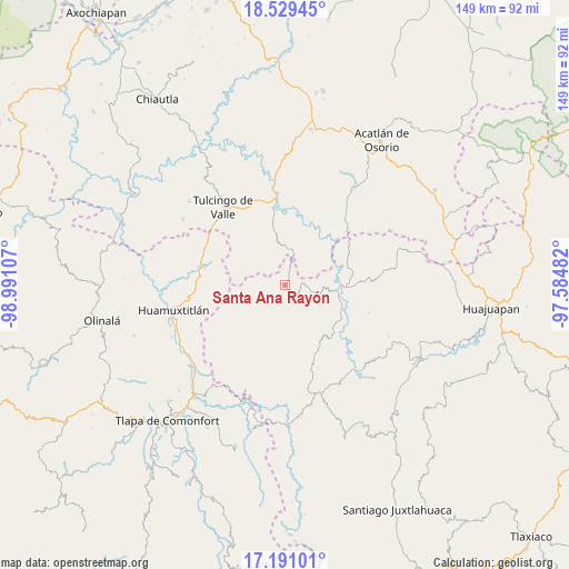
Santa Ana Rayón GPS coordinates[2]
17° 51' 41.364" North, 98° 17' 16.584" West
| Map corner | latitude | longitude |
|---|---|---|
| Upper-left | 18.52945°, | -98.99107° |
| Center: | 17.86149°, | -98.28794° |
| Lower-right: | 17.19101°, | -97.58482° |
| Map W x H: | 148.8×148.8 km | = 92.5×92.5mi |
| max Lat: | 32.7° ⇑80% North |
| Santa Ana Rayón: | 17.86149° |
| min Lat: | ⇓20% South 14.53588° |
| min Long | Santa Ana Rayó | max Long |
| -117.105° | -98.28794° | -86.73105° |
| W 60%⇐ | ⇒40% E |
Elevation
Elevation of Santa Ana Rayón is 1396 m = 4580 ft, and this is 142.3 m = 467 ft above average elevation for this country.
| Max E: |
3497 m = 11473 ft | 50.7% |
| Santa Ana Rayón | 1396 m 4580 ft | |
| Avg. | 1253.7 m = 4113 ft | |
Min E: |
-1 m = -3 ft | 49.3% |
See also: Mexico elevation on elevation.city.
Geographical zone
Santa Ana Rayón is located in North Torrid zone (between Equator and Tropic of Cancer). Distance of this Northern Tropic circle is 619.9 km =385.2 mi to North.| Distance of | km | miles | from Santa Ana Rayón |
|---|---|---|---|
| North Pole | 8021.1 | 4984.1 | to North |
| Arctic Circle | 5415.2 | 3364.8 | to North |
| Tropic Cancer | 619.9 | 385.2 | to North |
| Equator | 1986 | 1234 | to South |


Nearby cities:
15 places around Santa Ana Rayón: (largest is in red/bold)
• Guadalupe Ramírez
17.4 km =10.8 mi,  131°
131°
• Guadalupe Victoria
16.6 km =10.3 mi,  321°
321°
• Guadalupe del Recreo
8.3 km =5.2 mi,  214°
214°
• Ilamacingo
16.9 km =10.5 mi,  17°
17°
• Mariscala de Juárez
15.6 km =9.7 mi,  90°
90°
• Nicolás Hidalgo
17.6 km =10.9 mi,  119°
119°
• Olomatlán
9.6 km =6 mi,  11°
11°
• Progreso
19.7 km =12.2 mi,  352°
352°
• San Juan Ihualtepec
13.5 km =8.4 mi,  180°
180°
• San Juan la Ciénega
1.4 km =0.9 mi,  146°
146°
• San Luis Morelia
19.2 km =11.9 mi,  156°
156°
• San Miguel Tlaltepexi
15.5 km =9.6 mi,  292°
292°
• Santa Cruz Tacache de Mina
14.7 km =9.1 mi,  104°
104°
• Xixingo de los Reyes
13 km =8.1 mi, 286°
• Zapotitlán Lagunas
15.9 km =9.9 mi,  222°
222°
Sources, notices
• [Note1] Compared only with cities in Mexico existing in our database
• [Src1] Map data: © OpenStreetMap contributors (CC-BY-SA)
• [Src2] Other city data from geonames.org with taken over terms of usage.
• [Src3] Geographical zone / Annual Mean Temperature by Robert A. Rohde @ Wikipedia
