Mazatlán geodata
Mazatlán (Guerrero) is a populated place; located in Mexico in America/Mexico_City (GMT-6) time zone. With population of 5,316 people, there are 1742 cities with bigger population in this country. Compared to other cities in Mexico, 83.8% of cities are located further ↑North; 56.4% of cities are located further →East and 53.2% of cities have higher elevation than Mazatlán. Note1


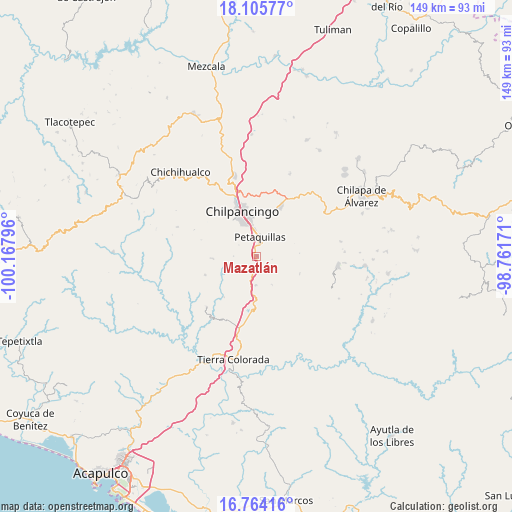
Mazatlán GPS coordinates[2]
17° 26' 10.32" North, 99° 27' 53.388" West
| Map corner | latitude | longitude |
|---|---|---|
| Upper-left | 18.10577°, | -100.16796° |
| Center: | 17.4362°, | -99.46483° |
| Lower-right: | 16.76416°, | -98.76171° |
| Map W x H: | 149.2×149.2 km | = 92.7×92.7mi |
| max Lat: | 32.7° ⇑83.8% North |
| Mazatlán: | 17.4362° |
| min Lat: | ⇓16.2% South 14.53588° |
| min Long | Mazatlán | max Long |
| -117.105° | -99.46483° | -86.73105° |
| W 43.6%⇐ | ⇒56.4% E |
Elevation
Elevation of Mazatlán is 1282 m = 4206 ft, and this is 28.3 m = 93 ft above average elevation for this country.
| Max E: |
3497 m = 11473 ft | 53.2% |
| Mazatlán | 1282 m 4206 ft | |
| Avg. | 1253.7 m = 4113 ft | |
Min E: |
-1 m = -3 ft | 46.8% |
See also: Mexico elevation on elevation.city.
Geographical zone
Mazatlán is located in North Torrid zone (between Equator and Tropic of Cancer). Distance of this Northern Tropic circle is 667.2 km =414.6 mi to North.| Distance of | km | miles | from Mazatlán |
|---|---|---|---|
| North Pole | 8068.3 | 5013.4 | to North |
| Arctic Circle | 5462.5 | 3394.2 | to North |
| Tropic Cancer | 667.2 | 414.6 | to North |
| Equator | 1938.7 | 1204.7 | to South |


Nearby cities:
15 places around Mazatlán: (largest is in red/bold)
• Acahuizotla
8.4 km =5.2 mi,  181°
181°
• Chilpancingo
13.4 km =8.3 mi,  341°
341°
• Coatomatitlán
15.4 km =9.6 mi,  75°
75°
• Coaxtlahuacán
13.3 km =8.3 mi,  111°
111°
• El Fresno
12.9 km =8 mi,  267°
267°
• La Esperanza
16.1 km =10 mi,  250°
250°
• Mochitlán
10.8 km =6.7 mi,  68°
68°
• Palo Blanco
3.6 km =2.2 mi, 182°
• Petaquillas
5.6 km =3.5 mi,  9°
9°
• San Martín
18.3 km =11.4 mi, 80°
• San Miguel
17.5 km =10.9 mi, 79°
• Tepechicotlán
7.4 km =4.6 mi,  45°
45°
• Tixtla de Guerrero
16.2 km =10.1 mi,  25°
25°
• Zacatzonapa
14.8 km =9.2 mi,  60°
60°
• Zoyatepec
15.3 km =9.5 mi,  219°
219°
Sources, notices
• [Note1] Compared only with cities in Mexico existing in our database
• [Src1] Map data: © OpenStreetMap contributors (CC-BY-SA)
• [Src2] Other city data from geonames.org with taken over terms of usage.
• [Src3] Geographical zone / Annual Mean Temperature by Robert A. Rohde @ Wikipedia
