Tixtla de Guerrero geodata
Tixtla de Guerrero (Guerrero) is a populated place; located in Mexico in America/Mexico_City (GMT-6) time zone. With population of 22,826 people, there are 450 cities with bigger population in this country. Compared to other cities in Mexico, 82.5% of cities are located further ↑North; 55.6% of cities are located further →East and 51.7% of cities have higher elevation than Tixtla de Guerrero. Note1


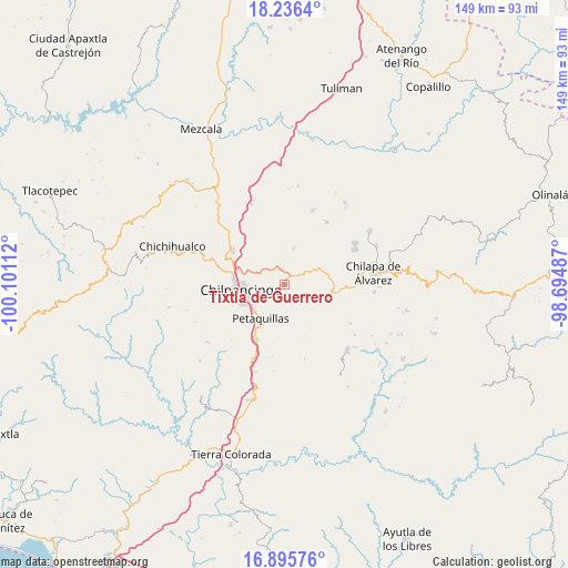
Tixtla de Guerrero GPS coordinates[2]
17° 34' 2.352" North, 99° 23' 52.764" West
| Map corner | latitude | longitude |
|---|---|---|
| Upper-left | 18.2364°, | -100.10112° |
| Center: | 17.56732°, | -99.39799° |
| Lower-right: | 16.89576°, | -98.69487° |
| Map W x H: | 149.1×149.1 km | = 92.6×92.6mi |
| max Lat: | 32.7° ⇑82.5% North |
| Tixtla de Guerrero: | 17.56732° |
| min Lat: | ⇓17.5% South 14.53588° |
| min Long | Tixtla de Guerr | max Long |
| -117.105° | -99.39799° | -86.73105° |
| W 44.4%⇐ | ⇒55.6% E |
Elevation
Elevation of Tixtla de Guerrero is 1354 m = 4442 ft, and this is 100.3 m = 329 ft above average elevation for this country.
| Max E: |
3497 m = 11473 ft | 51.7% |
| Tixtla de Guerrero | 1354 m 4442 ft | |
| Avg. | 1253.7 m = 4113 ft | |
Min E: |
-1 m = -3 ft | 48.3% |
See also: Mexico elevation on elevation.city.
Geographical zone
Tixtla de Guerrero is located in North Torrid zone (between Equator and Tropic of Cancer). Distance of this Northern Tropic circle is 652.6 km =405.5 mi to North.| Distance of | km | miles | from Tixtla de Guerrero |
|---|---|---|---|
| North Pole | 8053.8 | 5004.4 | to North |
| Arctic Circle | 5447.9 | 3385.2 | to North |
| Tropic Cancer | 652.6 | 405.5 | to North |
| Equator | 1953.3 | 1213.7 | to South |


Nearby cities:
15 places around Tixtla de Guerrero: (largest is in red/bold)
• Acatempa
9.1 km =5.7 mi,  21°
21°
• Almolonga
13.5 km =8.4 mi,  54°
54°
• Atliaca
9.7 km =6 mi,  14°
14°
• Chilacachapa
12.7 km =7.9 mi,  95°
95°
• Chilpancingo
11.6 km =7.2 mi,  260°
260°
• Coatomatitlán
13.2 km =8.2 mi,  143°
143°
• Cuonetzingo
14.7 km =9.1 mi,  107°
107°
• El Durazno
12.2 km =7.6 mi, 110°
• Mochitlán
11 km =6.8 mi,  164°
164°
• Monte Alegre
13.4 km =8.3 mi,  125°
125°
• Petaquillas
10.9 km =6.8 mi,  214°
214°
• San Miguel
15.3 km =9.5 mi, 138°
• Tepechicotlán
9.5 km =5.9 mi,  191°
191°
• Zacatzonapa
9.3 km =5.8 mi, 141°
• Zoquiapa
13.1 km =8.1 mi, 101°
Sources, notices
• [Note1] Compared only with cities in Mexico existing in our database
• [Src1] Map data: © OpenStreetMap contributors (CC-BY-SA)
• [Src2] Other city data from geonames.org with taken over terms of usage.
• [Src3] Geographical zone / Annual Mean Temperature by Robert A. Rohde @ Wikipedia
