Tepechicotlán geodata
Tepechicotlán (Guerrero) is a populated place; located in Mexico in America/Mexico_City (GMT-6) time zone. With population of 1,480 people, there are 5826 cities with bigger population in this country. Compared to other cities in Mexico, 83.3% of cities are located further ↑North; 55.8% of cities are located further →East and 59.2% of cities have higher elevation than Tepechicotlán. Note1


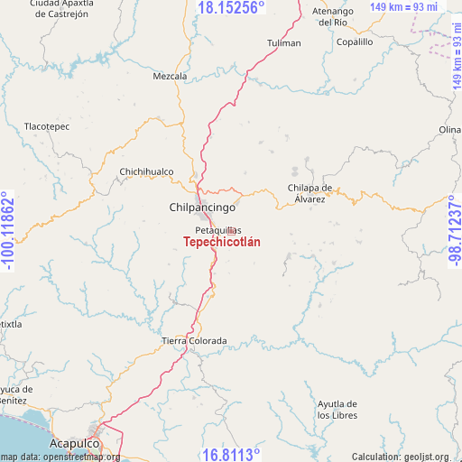
Tepechicotlán GPS coordinates[2]
17° 28' 59.412" North, 99° 24' 55.764" West
| Map corner | latitude | longitude |
|---|---|---|
| Upper-left | 18.15256°, | -100.11862° |
| Center: | 17.48317°, | -99.41549° |
| Lower-right: | 16.8113°, | -98.71237° |
| Map W x H: | 149.1×149.1 km | = 92.6×92.6mi |
| max Lat: | 32.7° ⇑83.3% North |
| Tepechicotlán: | 17.48317° |
| min Lat: | ⇓16.7% South 14.53588° |
| min Long | Tepechicotlán | max Long |
| -117.105° | -99.41549° | -86.73105° |
| W 44.2%⇐ | ⇒55.8% E |
Elevation
Elevation of Tepechicotlán is 1042 m = 3419 ft, and this is 211.7 m = 695 ft below average elevation for this country.
| Max E: |
3497 m = 11473 ft | 59.2% |
| Avg. | 1253.7 m = 4113 ft | |
| Tepechicotlán | 1042 m = 3419 ft | |
Min E: |
-1 m = -3 ft | 40.8% |
See also: Mexico elevation on elevation.city.
Geographical zone
Tepechicotlán is located in North Torrid zone (between Equator and Tropic of Cancer). Distance of this Northern Tropic circle is 662 km =411.3 mi to North.| Distance of | km | miles | from Tepechicotlán |
|---|---|---|---|
| North Pole | 8063.1 | 5010.2 | to North |
| Arctic Circle | 5457.2 | 3390.9 | to North |
| Tropic Cancer | 662 | 411.3 | to North |
| Equator | 1943.9 | 1207.9 | to South |


Nearby cities:
15 places around Tepechicotlán: (largest is in red/bold)
• Acahuizotla
14.7 km =9.1 mi,  202°
202°
• Chilpancingo
12.2 km =7.6 mi,  308°
308°
• Coatomatitlán
9.8 km =6.1 mi,  97°
97°
• Coaxtlahuacán
12.4 km =7.7 mi,  144°
144°
• El Durazno
14.2 km =8.8 mi,  69°
69°
• Mazatlán
7.4 km =4.6 mi,  225°
225°
• Mochitlán
4.9 km =3 mi, 104°
• Monte Alegre
12.8 km =8 mi,  83°
83°
• Palo Blanco
10.4 km =6.5 mi,  211°
211°
• Petaquillas
4.3 km =2.7 mi,  274°
274°
• Popoyatlajco
15.6 km =9.7 mi, 82°
• San Martín
13 km =8.1 mi, 99°
• San Miguel
12.2 km =7.6 mi, 100°
• Tixtla de Guerrero
9.5 km =5.9 mi,  11°
11°
• Zacatzonapa
7.9 km =4.9 mi, 74°
Sources, notices
• [Note1] Compared only with cities in Mexico existing in our database
• [Src1] Map data: © OpenStreetMap contributors (CC-BY-SA)
• [Src2] Other city data from geonames.org with taken over terms of usage.
• [Src3] Geographical zone / Annual Mean Temperature by Robert A. Rohde @ Wikipedia
