El Porvenir geodata
El Porvenir (Quintana Roo) is a populated place; located in Mexico in America/Cancun (GMT-5) time zone. With population of 505 people, there are 16660 cities with bigger population in this country. Compared to other cities in Mexico, 77.6% of cities are located further ↓South; 100% of cities are located further ←West and 93% of cities have higher elevation than El Porvenir. Note1


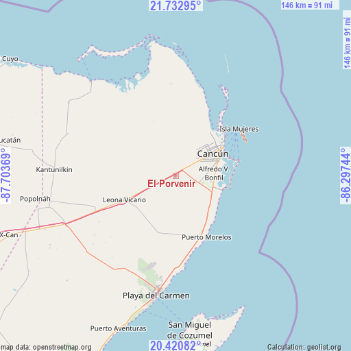
El Porvenir GPS coordinates[2]
21° 4' 41.988" North, 87° 0' 2.016" West
| Map corner | latitude | longitude |
|---|---|---|
| Upper-left | 21.73295°, | -87.70369° |
| Center: | 21.07833°, | -87.00056° |
| Lower-right: | 20.42082°, | -86.29744° |
| Map W x H: | 145.9×145.9 km | = 90.7×90.7mi |
| max Lat: | 32.7° ⇑22.4% North |
| El Porvenir: | 21.07833° |
| min Lat: | ⇓77.6% South 14.53588° |
| min Long | El Porvenir | max Long |
| -117.105° | -87.00056° | -86.73105° |
| W 100%⇐ | ⇒0% E |
Elevation
Elevation of El Porvenir is 17 m = 56 ft, and this is 1236.7 m = 4057 ft below average elevation for this country.
| Max E: |
3497 m = 11473 ft | 93% |
| Avg. | 1253.7 m = 4113 ft | |
| El Porvenir | 17 m = 56 ft | |
Min E: |
-1 m = -3 ft | 7% |
See also: Mexico elevation on elevation.city.
Geographical zone
El Porvenir is located in North Torrid zone (between Equator and Tropic of Cancer). Distance of this Northern Tropic circle is 262.2 km =162.9 mi to North.| Distance of | km | miles | from El Porvenir |
|---|---|---|---|
| North Pole | 7663.4 | 4761.8 | to North |
| Arctic Circle | 5057.5 | 3142.6 | to North |
| Tropic Cancer | 262.2 | 162.9 | to North |
| Equator | 2343.7 | 1456.3 | to South |


Nearby cities:
15 places around El Porvenir: (largest is in red/bold)
• Alfredo V. Bonfil
16 km =9.9 mi,  86°
86°
• Cancún
19.2 km =11.9 mi,  56°
56°
• Chiquilá
52.5 km =32.6 mi,  318°
318°
• El Cedral
58.8 km =36.5 mi,  256°
256°
• El Tintal
52.6 km =32.7 mi,  246°
246°
• Ignacio Zaragoza
58.7 km =36.5 mi, 248°
• Isla Mujeres
32.7 km =20.3 mi, 58°
• Kantunilkín
50.5 km =31.4 mi,  272°
272°
• Leona Vicario
23.1 km =14.4 mi,  244°
244°
• Playa del Carmen
50.8 km =31.6 mi,  189°
189°
• Popolnah
59.1 km =36.7 mi, 260°
• San Angel
48 km =29.8 mi,  291°
291°
• Solferino
53.8 km =33.4 mi,  304°
304°
• Vicente Guerrero
52.1 km =32.4 mi, 258°
• Zona Urbana Ejido Isla Mujeres
22.3 km =13.9 mi,  43°
43°
Sources, notices
• [Note1] Compared only with cities in Mexico existing in our database
• [Src1] Map data: © OpenStreetMap contributors (CC-BY-SA)
• [Src2] Other city data from geonames.org with taken over terms of usage.
• [Src3] Geographical zone / Annual Mean Temperature by Robert A. Rohde @ Wikipedia
