Playa del Carmen geodata
Playa del Carmen (Quintana Roo) is a populated place; located in Mexico in America/Cancun (GMT-5) time zone. With population of 149,923 people, there are 105 cities with bigger population in this country. Compared to other cities in Mexico, 70.5% of cities are located further ↓South; 100% of cities are located further ←West and 97.5% of cities have higher elevation than Playa del Carmen. Note1


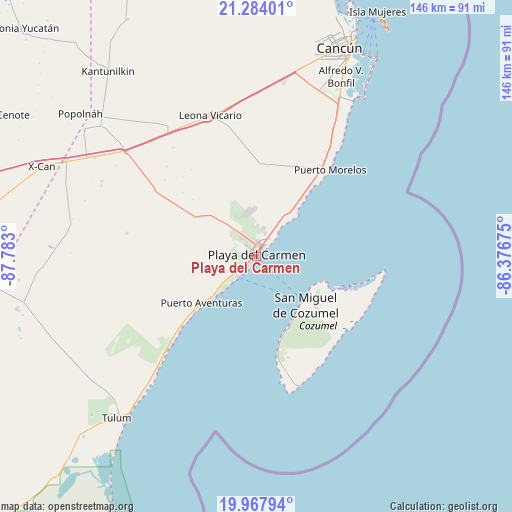
Playa del Carmen GPS coordinates[2]
20° 37' 38.64" North, 87° 4' 47.532" West
| Map corner | latitude | longitude |
|---|---|---|
| Upper-left | 21.28401°, | -87.783° |
| Center: | 20.6274°, | -87.07987° |
| Lower-right: | 19.96794°, | -86.37675° |
| Map W x H: | 146.3×146.3 km | = 90.9×90.9mi |
| max Lat: | 32.7° ⇑29.5% North |
| Playa del Carmen: | 20.6274° |
| min Lat: | ⇓70.5% South 14.53588° |
| min Long | Playa del Carme | max Long |
| -117.105° | -87.07987° | -86.73105° |
| W 100%⇐ | ⇒0% E |
Elevation
Elevation of Playa del Carmen is 9 m = 30 ft, and this is 1244.7 m = 4084 ft below average elevation for this country.
| Max E: |
3497 m = 11473 ft | 97.5% |
| Avg. | 1253.7 m = 4113 ft | |
| Playa del Carmen | 9 m = 30 ft | |
Min E: |
-1 m = -3 ft | 2.5% |
See also: Playa del Carmen elevation on elevation.city.
Geographical zone
Playa del Carmen is located in North Torrid zone (between Equator and Tropic of Cancer). Distance of this Northern Tropic circle is 312.4 km =194.1 mi to North.| Distance of | km | miles | from Playa del Carmen |
|---|---|---|---|
| North Pole | 7713.5 | 4792.9 | to North |
| Arctic Circle | 5107.6 | 3173.7 | to North |
| Tropic Cancer | 312.4 | 194.1 | to North |
| Equator | 2293.6 | 1425.2 | to South |


Nearby cities:
15 places around Playa del Carmen: (largest is in red/bold)
• Akumal
35.4 km =22 mi,  223°
223°
• Alfredo V. Bonfil
56.6 km =35.2 mi,  25°
25°
• Barceló Maya
23.3 km =14.5 mi,  228°
228°
• Ciudad Chemuyil
42.1 km =26.2 mi, 222°
• Cozumel
20.1 km =12.5 mi,  134°
134°
• El Ideal
55.9 km =34.7 mi,  300°
300°
• El Porvenir
50.8 km =31.6 mi,  9°
9°
• El Tintal
49.8 km =30.9 mi,  306°
306°
• Ignacio Zaragoza
54.2 km =33.7 mi, 301°
• Las Fincas
22.3 km =13.9 mi, 130°
• Leona Vicario
42.2 km =26.2 mi,  342°
342°
• Macario Gómez
60.1 km =37.3 mi,  239°
239°
• Puerto Aventuras
20.8 km =12.9 mi, 227°
• San Francisco
49 km =30.4 mi, 296°
• Vicente Guerrero
58.3 km =36.2 mi, 312°
Sources, notices
• [Note1] Compared only with cities in Mexico existing in our database
• [Src1] Map data: © OpenStreetMap contributors (CC-BY-SA)
• [Src2] Other city data from geonames.org with taken over terms of usage.
• [Src3] Geographical zone / Annual Mean Temperature by Robert A. Rohde @ Wikipedia
