Alfredo V. Bonfil geodata
Alfredo V. Bonfil (Quintana Roo) is a populated place; located in Mexico in America/Cancun (GMT-5) time zone. With population of 14,900 people, there are 648 cities with bigger population in this country. Compared to other cities in Mexico, 77.7% of cities are located further ↓South; 100% of cities are located further ←West and 98.7% of cities have higher elevation than Alfredo V. Bonfil. Note1


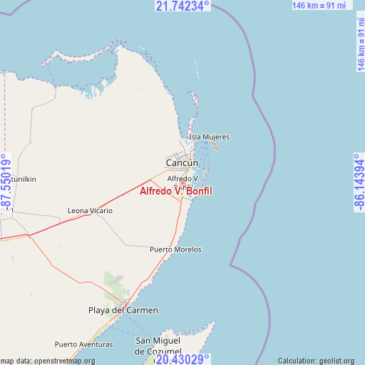
Alfredo V. Bonfil GPS coordinates[2]
21° 5' 15.936" North, 86° 50' 49.416" West
| Map corner | latitude | longitude |
|---|---|---|
| Upper-left | 21.74234°, | -87.55019° |
| Center: | 21.08776°, | -86.84706° |
| Lower-right: | 20.43029°, | -86.14394° |
| Map W x H: | 145.9×145.9 km | = 90.7×90.7mi |
| max Lat: | 32.7° ⇑22.3% North |
| Alfredo V. Bonfil: | 21.08776° |
| min Lat: | ⇓77.7% South 14.53588° |
| min Long | Alfredo V. Bonf | max Long |
| -117.105° | -86.84706° | -86.73105° |
| W 100%⇐ | ⇒0% E |
Elevation
Elevation of Alfredo V. Bonfil is 7 m = 23 ft, and this is 1246.7 m = 4090 ft below average elevation for this country.
| Max E: |
3497 m = 11473 ft | 98.7% |
| Avg. | 1253.7 m = 4113 ft | |
| Alfredo V. Bonfil | 7 m = 23 ft | |
Min E: |
-1 m = -3 ft | 1.3% |
See also: Mexico elevation on elevation.city.
Geographical zone
Alfredo V. Bonfil is located in North Torrid zone (between Equator and Tropic of Cancer). Distance of this Northern Tropic circle is 261.2 km =162.3 mi to North.| Distance of | km | miles | from Alfredo V. Bonfil |
|---|---|---|---|
| North Pole | 7662.3 | 4761.1 | to North |
| Arctic Circle | 5056.4 | 3141.9 | to North |
| Tropic Cancer | 261.2 | 162.3 | to North |
| Equator | 2344.7 | 1456.9 | to South |


Nearby cities:
15 places around Alfredo V. Bonfil: (largest is in red/bold)
• Cancún
9.6 km =6 mi,  0°
0°
• Chiquilá
63.5 km =39.5 mi,  307°
307°
• Cozumel
66.1 km =41.1 mi,  188°
188°
• El Porvenir
16 km =9.9 mi,  266°
266°
• El Tintal
67.9 km =42.2 mi,  251°
251°
• Isla Holbox
73.3 km =45.5 mi, 311°
• Isla Mujeres
20 km =12.4 mi,  37°
37°
• Kantunilkín
66.3 km =41.2 mi, 271°
• Las Fincas
66 km =41 mi, 186°
• Leona Vicario
38.4 km =23.9 mi, 253°
• Playa del Carmen
56.6 km =35.2 mi,  205°
205°
• San Angel
62.8 km =39 mi,  285°
285°
• Solferino
67.1 km =41.7 mi,  295°
295°
• Vicente Guerrero
68 km =42.3 mi,  260°
260°
• Zona Urbana Ejido Isla Mujeres
15.2 km =9.4 mi,  357°
357°
Sources, notices
• [Note1] Compared only with cities in Mexico existing in our database
• [Src1] Map data: © OpenStreetMap contributors (CC-BY-SA)
• [Src2] Other city data from geonames.org with taken over terms of usage.
• [Src3] Geographical zone / Annual Mean Temperature by Robert A. Rohde @ Wikipedia
