Mesa del Rancho geodata
Mesa del Rancho (Veracruz) is a populated place; located in Mexico in America/Mexico_City (GMT-6) time zone. With population of 857 people, there are 10207 cities with bigger population in this country. Compared to other cities in Mexico, 62.6% of cities are located further ↑North; 75.6% of cities are located further ←West and 55.6% of cities have higher elevation than Mesa del Rancho. Note1


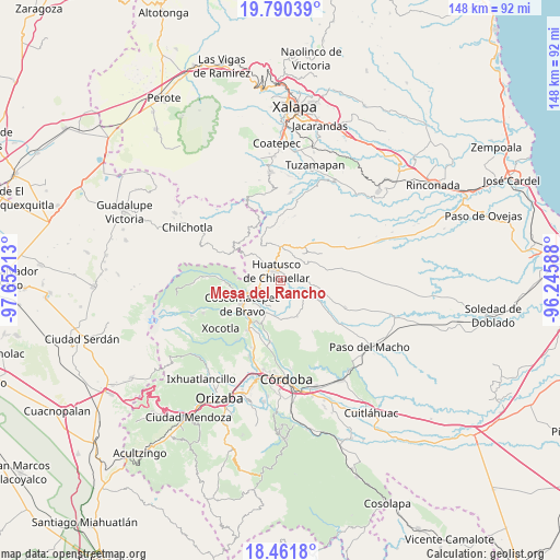
Mesa del Rancho GPS coordinates[2]
19° 7' 38.748" North, 96° 56' 56.4" West
| Map corner | latitude | longitude |
|---|---|---|
| Upper-left | 19.79039°, | -97.65213° |
| Center: | 19.12743°, | -96.949° |
| Lower-right: | 18.4618°, | -96.24588° |
| Map W x H: | 147.7×147.7 km | = 91.8×91.8mi |
| max Lat: | 32.7° ⇑62.6% North |
| Mesa del Rancho: | 19.12743° |
| min Lat: | ⇓37.4% South 14.53588° |
| min Long | Mesa del Rancho | max Long |
| -117.105° | -96.949° | -86.73105° |
| W 75.6%⇐ | ⇒24.4% E |
Elevation
Elevation of Mesa del Rancho is 1175 m = 3855 ft, and this is 78.7 m = 258 ft below average elevation for this country.
| Max E: |
3497 m = 11473 ft | 55.6% |
| Avg. | 1253.7 m = 4113 ft | |
| Mesa del Rancho | 1175 m = 3855 ft | |
Min E: |
-1 m = -3 ft | 44.4% |
See also: Mexico elevation on elevation.city.
Geographical zone
Mesa del Rancho is located in North Torrid zone (between Equator and Tropic of Cancer). Distance of this Northern Tropic circle is 479.1 km =297.7 mi to North.| Distance of | km | miles | from Mesa del Rancho |
|---|---|---|---|
| North Pole | 7880.3 | 4896.6 | to North |
| Arctic Circle | 5274.4 | 3277.4 | to North |
| Tropic Cancer | 479.1 | 297.7 | to North |
| Equator | 2126.8 | 1321.5 | to South |


Nearby cities:
15 places around Mesa del Rancho: (largest is in red/bold)
• Adolfo Ruiz Cortines (La Pastoría)
5.7 km =3.5 mi,  290°
290°
• Alta Luz
4.6 km =2.9 mi,  181°
181°
• Amatiopa
1.8 km =1.1 mi,  158°
158°
• Capulapa
7.1 km =4.4 mi,  116°
116°
• Colonia Francisco I. Madero
5.1 km =3.2 mi,  268°
268°
• Colonia Pastoría Cuatro
4.5 km =2.8 mi,  304°
304°
• Comapa
7.7 km =4.8 mi,  58°
58°
• Huatusco
3.1 km =1.9 mi,  320°
320°
• Ixcatla
6.6 km =4.1 mi,  151°
151°
• Ixpila
2.1 km =1.3 mi,  241°
241°
• Michapa
2.5 km =1.6 mi,  192°
192°
• Presidio
6.9 km =4.3 mi,  200°
200°
• Sochiapa
7.3 km =4.5 mi,  7°
7°
• Tlamatoca
4 km =2.5 mi, 161°
• Tomatlancillo
5.9 km =3.7 mi,  18°
18°
Sources, notices
• [Note1] Compared only with cities in Mexico existing in our database
• [Src1] Map data: © OpenStreetMap contributors (CC-BY-SA)
• [Src2] Other city data from geonames.org with taken over terms of usage.
• [Src3] Geographical zone / Annual Mean Temperature by Robert A. Rohde @ Wikipedia
