El Palmar geodata
El Palmar (Veracruz) is a populated place; located in Mexico in America/Mexico_City (GMT-6) time zone. With population of 1,089 people, there are 7989 cities with bigger population in this country. Compared to other cities in Mexico, 68.7% of cities are located further ↑North; 78.7% of cities are located further ←West and 72.9% of cities have higher elevation than El Palmar. Note1


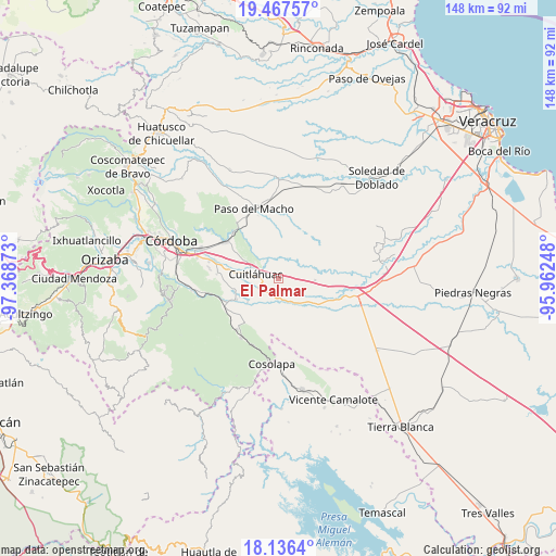
El Palmar GPS coordinates[2]
18° 48' 11.88" North, 96° 39' 56.16" West
| Map corner | latitude | longitude |
|---|---|---|
| Upper-left | 19.46757°, | -97.36873° |
| Center: | 18.8033°, | -96.6656° |
| Lower-right: | 18.1364°, | -95.96248° |
| Map W x H: | 148×148 km | = 92×92mi |
| max Lat: | 32.7° ⇑68.7% North |
| El Palmar: | 18.8033° |
| min Lat: | ⇓31.3% South 14.53588° |
| min Long | El Palmar | max Long |
| -117.105° | -96.6656° | -86.73105° |
| W 78.7%⇐ | ⇒21.3% E |
Elevation
Elevation of El Palmar is 290 m = 951 ft, and this is 963.7 m = 3162 ft below average elevation for this country.
| Max E: |
3497 m = 11473 ft | 72.9% |
| Avg. | 1253.7 m = 4113 ft | |
| El Palmar | 290 m = 951 ft | |
Min E: |
-1 m = -3 ft | 27.1% |
See also: Mexico elevation on elevation.city.
Geographical zone
El Palmar is located in North Torrid zone (between Equator and Tropic of Cancer). Distance of this Northern Tropic circle is 515.2 km =320.1 mi to North.| Distance of | km | miles | from El Palmar |
|---|---|---|---|
| North Pole | 7916.3 | 4919 | to North |
| Arctic Circle | 5310.4 | 3299.7 | to North |
| Tropic Cancer | 515.2 | 320.1 | to North |
| Equator | 2090.7 | 1299.1 | to South |


Nearby cities:
15 places around El Palmar: (largest is in red/bold)
• Arroyo Azul
3 km =1.9 mi,  318°
318°
• Bajo Grande
8.5 km =5.3 mi,  148°
148°
• Cuitláhuac
6.1 km =3.8 mi,  281°
281°
• División del Norte (Santa Rosa)
7.2 km =4.5 mi,  294°
294°
• El Maguey
8 km =5 mi, 294°
• El Tamarindo
7.7 km =4.8 mi, 275°
• Loma Angosta
2.5 km =1.6 mi,  205°
205°
• Los Mangos
10.4 km =6.5 mi, 279°
• Mata Gallina
5.7 km =3.5 mi,  69°
69°
• Mata Naranjo
5.8 km =3.6 mi,  240°
240°
• Mata Tenatito (Casco Hacienda)
9.1 km =5.7 mi,  178°
178°
• Paso Mulato
8.5 km =5.3 mi,  339°
339°
• Paso del Rosario
9 km =5.6 mi, 212°
• San Francisco (Mata Clara)
8.6 km =5.3 mi, 278°
• Toluquilla Buena Vista
10.4 km =6.5 mi,  232°
232°
Sources, notices
• [Note1] Compared only with cities in Mexico existing in our database
• [Src1] Map data: © OpenStreetMap contributors (CC-BY-SA)
• [Src2] Other city data from geonames.org with taken over terms of usage.
• [Src3] Geographical zone / Annual Mean Temperature by Robert A. Rohde @ Wikipedia
