La Guadalupe geodata
La Guadalupe (Veracruz) is a populated place; located in Mexico in America/Mexico_City (GMT-6) time zone. With population of 1,246 people, there are 6965 cities with bigger population in this country. Compared to other cities in Mexico, 71.6% of cities are located further ↓South; 68% of cities are located further ←West and 78.2% of cities have higher elevation than La Guadalupe. Note1


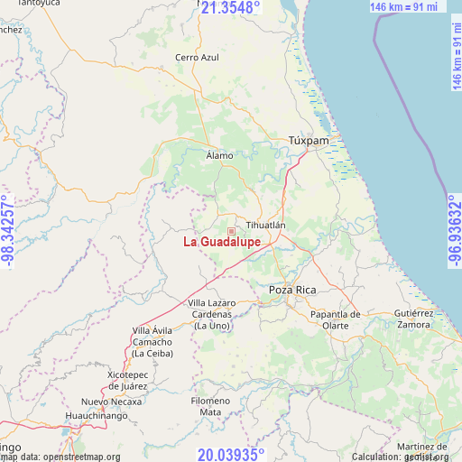
La Guadalupe GPS coordinates[2]
20° 41' 54.6" North, 97° 38' 21.984" West
| Map corner | latitude | longitude |
|---|---|---|
| Upper-left | 21.3548°, | -98.34257° |
| Center: | 20.6985°, | -97.63944° |
| Lower-right: | 20.03935°, | -96.93632° |
| Map W x H: | 146.3×146.3 km | = 90.9×90.9mi |
| max Lat: | 32.7° ⇑28.4% North |
| La Guadalupe: | 20.6985° |
| min Lat: | ⇓71.6% South 14.53588° |
| min Long | La Guadalupe | max Long |
| -117.105° | -97.63944° | -86.73105° |
| W 68%⇐ | ⇒32% E |
Elevation
Elevation of La Guadalupe is 126 m = 413 ft, and this is 1127.7 m = 3700 ft below average elevation for this country.
| Max E: |
3497 m = 11473 ft | 78.2% |
| Avg. | 1253.7 m = 4113 ft | |
| La Guadalupe | 126 m = 413 ft | |
Min E: |
-1 m = -3 ft | 21.8% |
See also: Mexico elevation on elevation.city.
Geographical zone
La Guadalupe is located in North Torrid zone (between Equator and Tropic of Cancer). Distance of this Northern Tropic circle is 304.5 km =189.2 mi to North.| Distance of | km | miles | from La Guadalupe |
|---|---|---|---|
| North Pole | 7705.6 | 4788 | to North |
| Arctic Circle | 5099.7 | 3168.8 | to North |
| Tropic Cancer | 304.5 | 189.2 | to North |
| Equator | 2301.5 | 1430.1 | to South |


Nearby cities:
15 places around La Guadalupe: (largest is in red/bold)
• Castillo de Teayo
5.7 km =3.5 mi,  9°
9°
• El Bejucal
12 km =7.5 mi,  350°
350°
• El Copal
11.8 km =7.3 mi,  139°
139°
• Enrique Rodríguez Cano (Zapotalillo)
10.4 km =6.5 mi,  114°
114°
• Francisco Villa
13.2 km =8.2 mi,  38°
38°
• Jiliapa Segundo
4.3 km =2.7 mi, 107°
• La Defensa
8.9 km =5.5 mi,  247°
247°
• Lima Vieja
10 km =6.2 mi,  4°
4°
• Mequetla
11.9 km =7.4 mi,  334°
334°
• Palma Real de Adentro
14.4 km =8.9 mi,  319°
319°
• Poza Azul de los Reyes
10 km =6.2 mi,  209°
209°
• Teayo
6.6 km =4.1 mi, 320°
• Tecomate
12.4 km =7.7 mi,  46°
46°
• Tihuatlan
11.2 km =7 mi,  80°
80°
• Tincontlán
14.7 km =9.1 mi,  338°
338°
Sources, notices
• [Note1] Compared only with cities in Mexico existing in our database
• [Src1] Map data: © OpenStreetMap contributors (CC-BY-SA)
• [Src2] Other city data from geonames.org with taken over terms of usage.
• [Src3] Geographical zone / Annual Mean Temperature by Robert A. Rohde @ Wikipedia
