Coahuitlán geodata
Coahuitlán (Veracruz) is a populated place; located in Mexico in America/Mexico_City (GMT-6) time zone. With population of 3,145 people, there are 2870 cities with bigger population in this country. Compared to other cities in Mexico, 62.7% of cities are located further ↓South; 66.9% of cities are located further ←West and 65.9% of cities have higher elevation than Coahuitlán. Note1


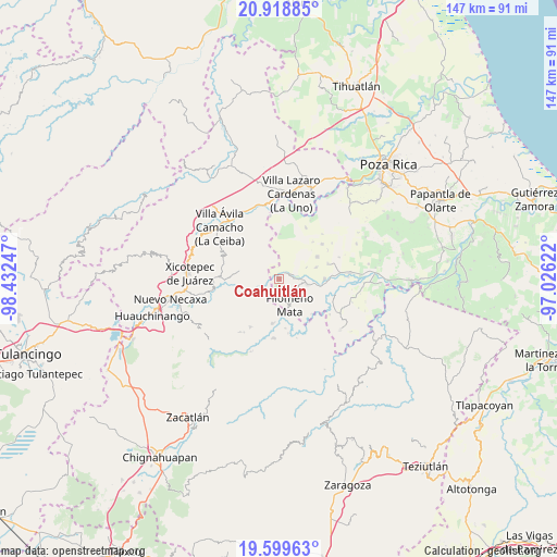
Coahuitlán GPS coordinates[2]
20° 15' 38.304" North, 97° 43' 45.624" West
| Map corner | latitude | longitude |
|---|---|---|
| Upper-left | 20.91885°, | -98.43247° |
| Center: | 20.26064°, | -97.72934° |
| Lower-right: | 19.59963°, | -97.02622° |
| Map W x H: | 146.7×146.7 km | = 91.2×91.2mi |
| max Lat: | 32.7° ⇑37.3% North |
| Coahuitlán: | 20.26064° |
| min Lat: | ⇓62.7% South 14.53588° |
| min Long | Coahuitlán | max Long |
| -117.105° | -97.72934° | -86.73105° |
| W 66.9%⇐ | ⇒33.1% E |
Elevation
Elevation of Coahuitlán is 641 m = 2103 ft, and this is 612.7 m = 2010 ft below average elevation for this country.
| Max E: |
3497 m = 11473 ft | 65.9% |
| Avg. | 1253.7 m = 4113 ft | |
| Coahuitlán | 641 m = 2103 ft | |
Min E: |
-1 m = -3 ft | 34.1% |
See also: Mexico elevation on elevation.city.
Geographical zone
Coahuitlán is located in North Torrid zone (between Equator and Tropic of Cancer). Distance of this Northern Tropic circle is 353.1 km =219.4 mi to North.| Distance of | km | miles | from Coahuitlán |
|---|---|---|---|
| North Pole | 7754.3 | 4818.3 | to North |
| Arctic Circle | 5148.4 | 3199.1 | to North |
| Tropic Cancer | 353.1 | 219.4 | to North |
| Equator | 2252.8 | 1399.8 | to South |


Nearby cities:
15 places around Coahuitlán: (largest is in red/bold)
• Bugambilias (La Cruz)
10.3 km =6.4 mi,  160°
160°
• Cerro Grande
5.5 km =3.4 mi,  116°
116°
• Cerro Verde
9.2 km =5.7 mi,  345°
345°
• Chicontla
10.7 km =6.6 mi,  260°
260°
• Coyutla
7.6 km =4.7 mi,  101°
101°
• Cruz Verde
7.8 km =4.8 mi,  66°
66°
• El Crucero
5.6 km =3.5 mi,  148°
148°
• El Panorama
10.3 km =6.4 mi, 72°
• Filomeno Mata
7.2 km =4.5 mi, 158°
• La Cruz
9.1 km =5.7 mi,  137°
137°
• Macedonio Alonso
4.2 km =2.6 mi, 68°
• Mecatlán
7.4 km =4.6 mi, 138°
• Progreso de Zaragoza
2.4 km =1.5 mi,  49°
49°
• San Pedro Tlaolantongo
8.3 km =5.2 mi,  246°
246°
• Tenangulto
9.2 km =5.7 mi,  322°
322°
Sources, notices
• [Note1] Compared only with cities in Mexico existing in our database
• [Src1] Map data: © OpenStreetMap contributors (CC-BY-SA)
• [Src2] Other city data from geonames.org with taken over terms of usage.
• [Src3] Geographical zone / Annual Mean Temperature by Robert A. Rohde @ Wikipedia
