Piedra Labrada geodata
Piedra Labrada (Veracruz) is a populated place; located in Mexico in America/Mexico_City (GMT-6) time zone. With population of 512 people, there are 16417 cities with bigger population in this country. Compared to other cities in Mexico, 73.8% of cities are located further ↑North; 85.1% of cities are located further ←West and 78.1% of cities have higher elevation than Piedra Labrada. Note1


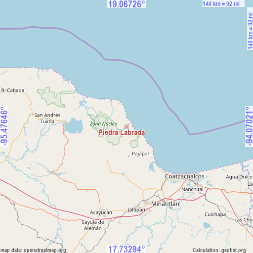
Piedra Labrada GPS coordinates[2]
18° 24' 5.004" North, 94° 46' 23.988" West
| Map corner | latitude | longitude |
|---|---|---|
| Upper-left | 19.06726°, | -95.47646° |
| Center: | 18.40139°, | -94.77333° |
| Lower-right: | 17.73294°, | -94.07021° |
| Map W x H: | 148.4×148.4 km | = 92.2×92.2mi |
| max Lat: | 32.7° ⇑73.8% North |
| Piedra Labrada: | 18.40139° |
| min Lat: | ⇓26.2% South 14.53588° |
| min Long | Piedra Labrada | max Long |
| -117.105° | -94.77333° | -86.73105° |
| W 85.1%⇐ | ⇒14.9% E |
Elevation
Elevation of Piedra Labrada is 130 m = 427 ft, and this is 1123.7 m = 3687 ft below average elevation for this country.
| Max E: |
3497 m = 11473 ft | 78.1% |
| Avg. | 1253.7 m = 4113 ft | |
| Piedra Labrada | 130 m = 427 ft | |
Min E: |
-1 m = -3 ft | 21.9% |
See also: Mexico elevation on elevation.city.
Geographical zone
Piedra Labrada is located in North Torrid zone (between Equator and Tropic of Cancer). Distance of this Northern Tropic circle is 559.9 km =347.9 mi to North.| Distance of | km | miles | from Piedra Labrada |
|---|---|---|---|
| North Pole | 7961 | 4946.7 | to North |
| Arctic Circle | 5355.1 | 3327.5 | to North |
| Tropic Cancer | 559.9 | 347.9 | to North |
| Equator | 2046 | 1271.3 | to South |


Nearby cities:
15 places around Piedra Labrada: (largest is in red/bold)
• Colonia la Magdalena
24.4 km =15.2 mi,  251°
251°
• Coxcoapan
25 km =15.5 mi,  292°
292°
• Encino Amarillo
12.6 km =7.8 mi,  189°
189°
• Ixhuapán
25.2 km =15.7 mi, 186°
• Los Arrecifes
17.1 km =10.6 mi,  329°
329°
• Mecayapan
21.3 km =13.2 mi,  198°
198°
• Ocotal Chico
18.4 km =11.4 mi,  209°
209°
• Ocozotepec
21.5 km =13.4 mi,  222°
222°
• Pajapan
17.7 km =11 mi,  150°
150°
• San Fernando
18.8 km =11.7 mi, 218°
• San Juan Volador
20 km =12.4 mi,  140°
140°
• Soteapan
21.4 km =13.3 mi, 209°
• Tatahuicapan
17.3 km =10.7 mi,  175°
175°
• Tebanca
25.4 km =15.8 mi,  269°
269°
• Ursulo Galván
1.1 km =0.7 mi, 218°
Sources, notices
• [Note1] Compared only with cities in Mexico existing in our database
• [Src1] Map data: © OpenStreetMap contributors (CC-BY-SA)
• [Src2] Other city data from geonames.org with taken over terms of usage.
• [Src3] Geographical zone / Annual Mean Temperature by Robert A. Rohde @ Wikipedia
