Nueva Esperanza geodata
Nueva Esperanza (Veracruz) is a populated place; located in Mexico in America/Mexico_City (GMT-6) time zone. With population of 883 people, there are 9888 cities with bigger population in this country. Compared to other cities in Mexico, 83.2% of cities are located further ↑North; 85.7% of cities are located further ←West and 89.4% of cities have higher elevation than Nueva Esperanza. Note1


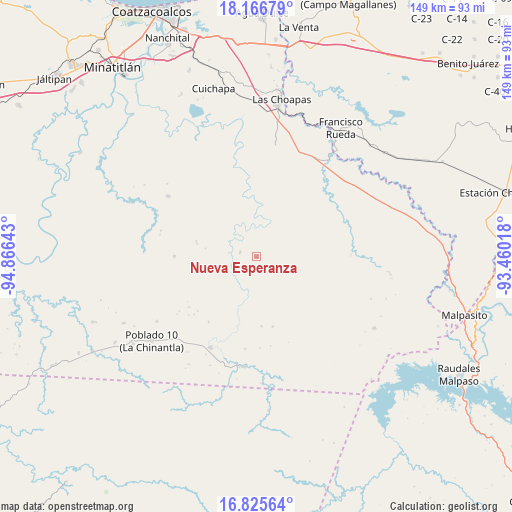
Nueva Esperanza GPS coordinates[2]
17° 29' 50.82" North, 94° 9' 47.88" West
| Map corner | latitude | longitude |
|---|---|---|
| Upper-left | 18.16679°, | -94.86643° |
| Center: | 17.49745°, | -94.1633° |
| Lower-right: | 16.82564°, | -93.46018° |
| Map W x H: | 149.1×149.1 km | = 92.6×92.6mi |
| max Lat: | 32.7° ⇑83.2% North |
| Nueva Esperanza: | 17.49745° |
| min Lat: | ⇓16.8% South 14.53588° |
| min Long | Nueva Esperanza | max Long |
| -117.105° | -94.1633° | -86.73105° |
| W 85.7%⇐ | ⇒14.3% E |
Elevation
Elevation of Nueva Esperanza is 26 m = 85 ft, and this is 1227.7 m = 4028 ft below average elevation for this country.
| Max E: |
3497 m = 11473 ft | 89.4% |
| Avg. | 1253.7 m = 4113 ft | |
| Nueva Esperanza | 26 m = 85 ft | |
Min E: |
-1 m = -3 ft | 10.6% |
See also: Mexico elevation on elevation.city.
Geographical zone
Nueva Esperanza is located in North Torrid zone (between Equator and Tropic of Cancer). Distance of this Northern Tropic circle is 660.4 km =410.4 mi to North.| Distance of | km | miles | from Nueva Esperanza |
|---|---|---|---|
| North Pole | 8061.5 | 5009.2 | to North |
| Arctic Circle | 5455.6 | 3390 | to North |
| Tropic Cancer | 660.4 | 410.4 | to North |
| Equator | 1945.5 | 1208.9 | to South |


Nearby cities:
15 places around Nueva Esperanza: (largest is in red/bold)
• Adalberto Tejeda
11.7 km =7.3 mi,  322°
322°
• Felipe Ángeles
40.2 km =25 mi,  121°
121°
• Fernando López Arias
14.6 km =9.1 mi,  292°
292°
• Graciano Sánchez
27.8 km =17.3 mi,  88°
88°
• Gustavo Díaz Ordaz
27.3 km =17 mi, 319°
• Helio García Alfaro
29.6 km =18.4 mi,  206°
206°
• Ignacio López Rayón
32.5 km =20.2 mi, 89°
• La Breña
23.8 km =14.8 mi,  270°
270°
• La Chinantla
39 km =24.2 mi,  231°
231°
• La Horqueta (Poblado Doce)
32.2 km =20 mi,  187°
187°
• Las Carolinas
34.5 km =21.4 mi,  237°
237°
• Niños Héroes
36.3 km =22.6 mi,  258°
258°
• Nueva Tabasqueña
17.7 km =11 mi,  80°
80°
• Nuevo Atoyac
31.1 km =19.3 mi,  304°
304°
• Poblado 10
39.2 km =24.4 mi, 231°
Sources, notices
• [Note1] Compared only with cities in Mexico existing in our database
• [Src1] Map data: © OpenStreetMap contributors (CC-BY-SA)
• [Src2] Other city data from geonames.org with taken over terms of usage.
• [Src3] Geographical zone / Annual Mean Temperature by Robert A. Rohde @ Wikipedia
