El Chino geodata
El Chino (Zacatecas) is a populated place; located in Mexico in America/Mexico_City (GMT-6) time zone. With population of 713 people, there are 12219 cities with bigger population in this country. Compared to other cities in Mexico, 85.8% of cities are located further ↓South; 78.7% of cities are located further →East and 85.4% of cities have lower elevation than El Chino. Note1


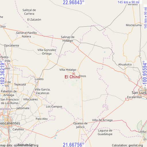
El Chino GPS coordinates[2]
22° 19' 10.236" North, 101° 39' 32.616" West
| Map corner | latitude | longitude |
|---|---|---|
| Upper-left | 22.96843°, | -102.36219° |
| Center: | 22.31951°, | -101.65906° |
| Lower-right: | 21.66756°, | -100.95594° |
| Map W x H: | 144.6×144.6 km | = 89.9×89.9mi |
| max Lat: | 32.7° ⇑14.2% North |
| El Chino: | 22.31951° |
| min Lat: | ⇓85.8% South 14.53588° |
| min Long | El Chino | max Long |
| -117.105° | -101.65906° | -86.73105° |
| W 21.3%⇐ | ⇒78.7% E |
Elevation
Elevation of El Chino is 2268 m = 7441 ft, and this is 1014.3 m = 3328 ft above average elevation for this country.
| Max E: |
3497 m = 11473 ft | 14.6% |
| El Chino | 2268 m 7441 ft | |
| Avg. | 1253.7 m = 4113 ft | |
Min E: |
-1 m = -3 ft | 85.4% |
See also: Mexico elevation on elevation.city.
Geographical zone
El Chino is located in North Torrid zone (between Equator and Tropic of Cancer). Distance of this Northern Tropic circle is 124.2 km =77.2 mi to North.| Distance of | km | miles | from El Chino |
|---|---|---|---|
| North Pole | 7525.4 | 4676.1 | to North |
| Arctic Circle | 4919.5 | 3056.8 | to North |
| Tropic Cancer | 124.2 | 77.2 | to North |
| Equator | 2481.7 | 1542.1 | to South |


Nearby cities:
15 places around El Chino: (largest is in red/bold)
• Caballerías (Caballería Villa Hidalgo)
7.4 km =4.6 mi,  4°
4°
• Canoas
12.5 km =7.8 mi,  304°
304°
• El Fraile
8.5 km =5.3 mi,  252°
252°
• El Refugio
11.9 km =7.4 mi, 298°
• El Tepetate
9.4 km =5.8 mi,  330°
330°
• Estancia de Guadalupe
4.3 km =2.7 mi,  177°
177°
• La Lobeña
5.3 km =3.3 mi,  234°
234°
• La Pachona
13.1 km =8.1 mi,  218°
218°
• La Victoria
7.6 km =4.7 mi,  156°
156°
• Pedregoso
12.6 km =7.8 mi, 233°
• Pinos
9 km =5.6 mi,  107°
107°
• Presa de Valenzuela
3.5 km =2.2 mi,  337°
337°
• Rancho Nuevo de Morelos (De Guadalupe)
13.2 km =8.2 mi,  280°
280°
• San Andrés
12.2 km =7.6 mi,  33°
33°
• Villa Hidalgo
6.9 km =4.3 mi,  306°
306°
Sources, notices
• [Note1] Compared only with cities in Mexico existing in our database
• [Src1] Map data: © OpenStreetMap contributors (CC-BY-SA)
• [Src2] Other city data from geonames.org with taken over terms of usage.
• [Src3] Geographical zone / Annual Mean Temperature by Robert A. Rohde @ Wikipedia
