San Andrés geodata
San Andrés (Zacatecas) is a populated place; located in Mexico in America/Mexico_City (GMT-6) time zone. With population of 581 people, there are 14753 cities with bigger population in this country. Compared to other cities in Mexico, 86.3% of cities are located further ↓South; 78.1% of cities are located further →East and 84% of cities have lower elevation than San Andrés. Note1


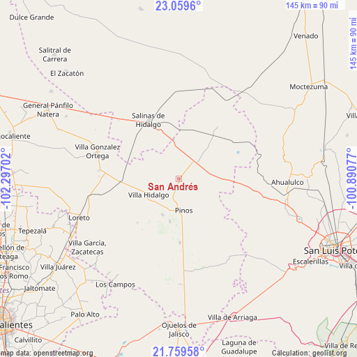
San Andrés GPS coordinates[2]
22° 24' 39.996" North, 101° 35' 38.004" West
| Map corner | latitude | longitude |
|---|---|---|
| Upper-left | 23.0596°, | -102.29702° |
| Center: | 22.41111°, | -101.59389° |
| Lower-right: | 21.75958°, | -100.89077° |
| Map W x H: | 144.5×144.6 km | = 89.8×89.9mi |
| max Lat: | 32.7° ⇑13.7% North |
| San Andrés: | 22.41111° |
| min Lat: | ⇓86.3% South 14.53588° |
| min Long | San Andrés | max Long |
| -117.105° | -101.59389° | -86.73105° |
| W 21.9%⇐ | ⇒78.1% E |
Elevation
Elevation of San Andrés is 2243 m = 7359 ft, and this is 989.3 m = 3246 ft above average elevation for this country.
| Max E: |
3497 m = 11473 ft | 16% |
| San Andrés | 2243 m 7359 ft | |
| Avg. | 1253.7 m = 4113 ft | |
Min E: |
-1 m = -3 ft | 84% |
See also: Mexico elevation on elevation.city.
Geographical zone
San Andrés is located in North Torrid zone (between Equator and Tropic of Cancer). Distance of this Northern Tropic circle is 114 km =70.8 mi to North.| Distance of | km | miles | from San Andrés |
|---|---|---|---|
| North Pole | 7515.2 | 4669.7 | to North |
| Arctic Circle | 4909.3 | 3050.5 | to North |
| Tropic Cancer | 114 | 70.8 | to North |
| Equator | 2491.9 | 1548.4 | to South |


Nearby cities:
15 places around San Andrés: (largest is in red/bold)
• Ahijaderos
13.3 km =8.3 mi,  110°
110°
• Caballerías (Caballería Villa Hidalgo)
6.7 km =4.2 mi,  245°
245°
• El Chino
12.2 km =7.6 mi,  213°
213°
• El Tepetate
11.4 km =7.1 mi,  259°
259°
• Estancia de Guadalupe
15.9 km =9.9 mi,  204°
204°
• Guadalupe de los Sauces
16.4 km =10.2 mi, 110°
• La Ballena
12.7 km =7.9 mi,  292°
292°
• La Lobeña
17.2 km =10.7 mi,  219°
219°
• La Pendencia
3.5 km =2.2 mi,  31°
31°
• Pinos
13 km =8.1 mi,  171°
171°
• Presa de Valenzuela
10.6 km =6.6 mi,  228°
228°
• Santa Ana
12.5 km =7.8 mi,  99°
99°
• Santiago
14.7 km =9.1 mi,  70°
70°
• Trinidad Norte
9.4 km =5.8 mi,  56°
56°
• Villa Hidalgo
13.6 km =8.5 mi,  243°
243°
Sources, notices
• [Note1] Compared only with cities in Mexico existing in our database
• [Src1] Map data: © OpenStreetMap contributors (CC-BY-SA)
• [Src2] Other city data from geonames.org with taken over terms of usage.
• [Src3] Geographical zone / Annual Mean Temperature by Robert A. Rohde @ Wikipedia
