Presa de Valenzuela geodata
Presa de Valenzuela (Zacatecas) is a populated place; located in Mexico in America/Mexico_City (GMT-6) time zone. With population of 742 people, there are 11790 cities with bigger population in this country. Compared to other cities in Mexico, 86% of cities are located further ↓South; 78.8% of cities are located further →East and 84.3% of cities have lower elevation than Presa de Valenzuela. Note1


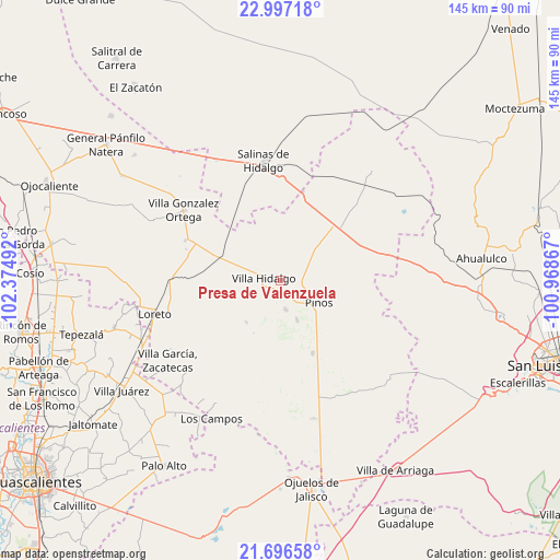
Presa de Valenzuela GPS coordinates[2]
22° 20' 54.24" North, 101° 40' 18.444" West
| Map corner | latitude | longitude |
|---|---|---|
| Upper-left | 22.99718°, | -102.37492° |
| Center: | 22.3484°, | -101.67179° |
| Lower-right: | 21.69658°, | -100.96867° |
| Map W x H: | 144.6×144.6 km | = 89.9×89.9mi |
| max Lat: | 32.7° ⇑14% North |
| Presa de Valenzuela: | 22.3484° |
| min Lat: | ⇓86% South 14.53588° |
| min Long | Presa de Valenz | max Long |
| -117.105° | -101.67179° | -86.73105° |
| W 21.2%⇐ | ⇒78.8% E |
Elevation
Elevation of Presa de Valenzuela is 2248 m = 7375 ft, and this is 994.3 m = 3262 ft above average elevation for this country.
| Max E: |
3497 m = 11473 ft | 15.7% |
| Presa de Valenzuela | 2248 m 7375 ft | |
| Avg. | 1253.7 m = 4113 ft | |
Min E: |
-1 m = -3 ft | 84.3% |
See also: Mexico elevation on elevation.city.
Geographical zone
Presa de Valenzuela is located in North Torrid zone (between Equator and Tropic of Cancer). Distance of this Northern Tropic circle is 121 km =75.2 mi to North.| Distance of | km | miles | from Presa de Valenzuela |
|---|---|---|---|
| North Pole | 7522.2 | 4674.1 | to North |
| Arctic Circle | 4916.3 | 3054.8 | to North |
| Tropic Cancer | 121 | 75.2 | to North |
| Equator | 2484.9 | 1544 | to South |


Nearby cities:
15 places around Presa de Valenzuela: (largest is in red/bold)
• Caballerías (Caballería Villa Hidalgo)
4.6 km =2.9 mi,  24°
24°
• Canoas
9.7 km =6 mi,  293°
293°
• El Chino
3.5 km =2.2 mi,  157°
157°
• El Fraile
8.9 km =5.5 mi,  229°
229°
• El Refugio
9.5 km =5.9 mi,  284°
284°
• El Salitre
12.7 km =7.9 mi,  298°
298°
• El Tepetate
5.9 km =3.7 mi,  326°
326°
• Estancia de Guadalupe
7.7 km =4.8 mi,  168°
168°
• La Ballena
12.5 km =7.8 mi,  342°
342°
• La Lobeña
6.9 km =4.3 mi,  205°
205°
• La Victoria
11.1 km =6.9 mi, 156°
• Pinos
11.5 km =7.1 mi,  120°
120°
• Rancho Nuevo de Morelos (De Guadalupe)
11.7 km =7.3 mi,  265°
265°
• San Andrés
10.6 km =6.6 mi,  48°
48°
• Villa Hidalgo
4.3 km =2.7 mi, 282°
Sources, notices
• [Note1] Compared only with cities in Mexico existing in our database
• [Src1] Map data: © OpenStreetMap contributors (CC-BY-SA)
• [Src2] Other city data from geonames.org with taken over terms of usage.
• [Src3] Geographical zone / Annual Mean Temperature by Robert A. Rohde @ Wikipedia
