Pinos geodata
Pinos (Zacatecas) is a seat of a second-order administrative division; located in Mexico in America/Mexico_City (GMT-6) time zone. With population of 5,611 people, there are 1661 cities with bigger population in this country. Compared to other cities in Mexico, 85.7% of cities are located further ↓South; 78% of cities are located further →East and 91.3% of cities have lower elevation than Pinos. Note1


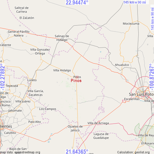
Pinos GPS coordinates[2]
22° 17' 44.556" North, 101° 34' 32.844" West
| Map corner | latitude | longitude |
|---|---|---|
| Upper-left | 22.94474°, | -102.27892° |
| Center: | 22.29571°, | -101.57579° |
| Lower-right: | 21.64365°, | -100.87267° |
| Map W x H: | 144.7×144.7 km | = 89.9×89.9mi |
| max Lat: | 32.7° ⇑14.3% North |
| Pinos: | 22.29571° |
| min Lat: | ⇓85.7% South 14.53588° |
| min Long | Pinos | max Long |
| -117.105° | -101.57579° | -86.73105° |
| W 22%⇐ | ⇒78% E |
Elevation
Elevation of Pinos is 2453 m = 8048 ft, and this is 1199.3 m = 3935 ft above average elevation for this country.
| Max E: |
3497 m = 11473 ft | 8.7% |
| Pinos | 2453 m 8048 ft | |
| Avg. | 1253.7 m = 4113 ft | |
Min E: |
-1 m = -3 ft | 91.3% |
See also: Mexico elevation on elevation.city.
Geographical zone
Pinos is located in North Torrid zone (between Equator and Tropic of Cancer). Distance of this Northern Tropic circle is 126.9 km =78.9 mi to North.| Distance of | km | miles | from Pinos |
|---|---|---|---|
| North Pole | 7528 | 4677.7 | to North |
| Arctic Circle | 4922.1 | 3058.5 | to North |
| Tropic Cancer | 126.9 | 78.9 | to North |
| Equator | 2479.1 | 1540.4 | to South |


Nearby cities:
15 places around Pinos: (largest is in red/bold)
• Ahijaderos
13.5 km =8.4 mi,  52°
52°
• Caballerías (Caballería Villa Hidalgo)
12.8 km =8 mi,  321°
321°
• El Chino
9 km =5.6 mi,  287°
287°
• El Fraile
16.7 km =10.4 mi,  270°
270°
• El Obraje
12.9 km =8 mi,  186°
186°
• El Tepetate
17 km =10.6 mi,  309°
309°
• Estancia de Guadalupe
8.6 km =5.3 mi,  258°
258°
• Guadalupe de los Sauces
15.2 km =9.4 mi,  62°
62°
• La Lobeña
12.9 km =8 mi, 268°
• La Pendencia
15.8 km =9.8 mi,  359°
359°
• La Victoria
7 km =4.3 mi,  232°
232°
• Presa de Valenzuela
11.5 km =7.1 mi,  300°
300°
• San Andrés
13 km =8.1 mi,  351°
351°
• Santa Ana
15 km =9.3 mi,  44°
44°
• Villa Hidalgo
15.6 km =9.7 mi, 295°
Sources, notices
• [Note1] Compared only with cities in Mexico existing in our database
• [Src1] Map data: © OpenStreetMap contributors (CC-BY-SA)
• [Src2] Other city data from geonames.org with taken over terms of usage.
• [Src3] Geographical zone / Annual Mean Temperature by Robert A. Rohde @ Wikipedia
