Pancho Villa geodata
Pancho Villa (Chihuahua) is a populated place; located in Mexico in America/Chihuahua (GMT-6) time zone. With population of 812 people, there are 10760 cities with bigger population in this country. Compared to other cities in Mexico, 98.9% of cities are located further ↓South; 96.5% of cities are located further →East and 50.2% of cities have lower elevation than Pancho Villa. Note1


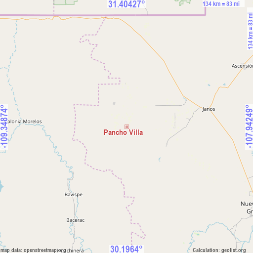
Pancho Villa GPS coordinates[2]
30° 48' 8.028" North, 108° 38' 44.196" West
| Map corner | latitude | longitude |
|---|---|---|
| Upper-left | 31.40427°, | -109.34874° |
| Center: | 30.80223°, | -108.64561° |
| Lower-right: | 30.1964°, | -107.94249° |
| Map W x H: | 134.3×134.3 km | = 83.5×83.5mi |
| max Lat: | 32.7° ⇑1.1% North |
| Pancho Villa: | 30.80223° |
| min Lat: | ⇓98.9% South 14.53588° |
| min Long | Pancho Villa | max Long |
| -117.105° | -108.64561° | -86.73105° |
| W 3.5%⇐ | ⇒96.5% E |
Elevation
Elevation of Pancho Villa is 1444 m = 4738 ft, and this is 190.3 m = 624 ft above average elevation for this country.
| Max E: |
3497 m = 11473 ft | 49.8% |
| Pancho Villa | 1444 m 4738 ft | |
| Avg. | 1253.7 m = 4113 ft | |
Min E: |
-1 m = -3 ft | 50.2% |
See also: Mexico elevation on elevation.city.
Geographical zone
Pancho Villa is located in North temperate zone (between Tropic of Cancer and the Arctic Circle). Distance of this Northern Tropic circle is 819 km =508.9 mi to South.| Distance of | km | miles | from Pancho Villa |
|---|---|---|---|
| North Pole | 6582.2 | 4090 | to North |
| Arctic Circle | 3976.3 | 2470.8 | to North |
| Tropic Cancer | 819 | 508.9 | to South |
| Equator | 3424.9 | 2128.1 | to South |


Nearby cities:
15 places around Pancho Villa: (largest is in red/bold)
• Ascención
71.3 km =44.3 mi,  62°
62°
• Ascensión
69.8 km =43.4 mi, 62°
• Bacerac
56.7 km =35.2 mi,  208°
208°
• Bavispe
45.6 km =28.3 mi,  218°
218°
• Buena Fe
84.5 km =52.5 mi,  125°
125°
• Casas Grandes
80.8 km =50.2 mi, 125°
• Esqueda
90.6 km =56.3 mi,  264°
264°
• Fernández Leal
34.8 km =21.6 mi,  81°
81°
• Fronteras
87.9 km =54.6 mi,  276°
276°
• Huachinera
72.3 km =44.9 mi,  204°
204°
• Janos
44.2 km =27.5 mi, 77°
• Juárez
77.1 km =47.9 mi,  135°
135°
• Monte Verde
14.1 km =8.8 mi,  331°
331°
• Nuevo Casas Grandes
82.4 km =51.2 mi,  121°
121°
• Tres Álamos
33.2 km =20.6 mi,  85°
85°
Sources, notices
• [Note1] Compared only with cities in Mexico existing in our database
• [Src1] Map data: © OpenStreetMap contributors (CC-BY-SA)
• [Src2] Other city data from geonames.org with taken over terms of usage.
• [Src3] Geographical zone / Annual Mean Temperature by Robert A. Rohde @ Wikipedia
