El Tecuán geodata
El Tecuán (Jalisco) is a populated place; located in Mexico in America/Mexico_City (GMT-6) time zone. With population of 2,384 people, there are 3700 cities with bigger population in this country. Compared to other cities in Mexico, 82.3% of cities are located further ↓South; 81.1% of cities are located further →East and 72.2% of cities have lower elevation than El Tecuán. Note1


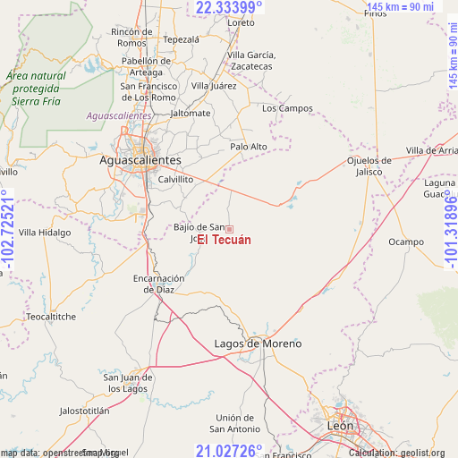
El Tecuán GPS coordinates[2]
21° 40' 55.596" North, 102° 1' 19.488" West
| Map corner | latitude | longitude |
|---|---|---|
| Upper-left | 22.33399°, | -102.72521° |
| Center: | 21.68211°, | -102.02208° |
| Lower-right: | 21.02726°, | -101.31896° |
| Map W x H: | 145.3×145.3 km | = 90.3×90.3mi |
| max Lat: | 32.7° ⇑17.7% North |
| El Tecuán: | 21.68211° |
| min Lat: | ⇓82.3% South 14.53588° |
| min Long | El Tecuán | max Long |
| -117.105° | -102.02208° | -86.73105° |
| W 18.9%⇐ | ⇒81.1% E |
Elevation
Elevation of El Tecuán is 1971 m = 6467 ft, and this is 717.3 m = 2353 ft above average elevation for this country.
| Max E: |
3497 m = 11473 ft | 27.8% |
| El Tecuán | 1971 m 6467 ft | |
| Avg. | 1253.7 m = 4113 ft | |
Min E: |
-1 m = -3 ft | 72.2% |
See also: Mexico elevation on elevation.city.
Geographical zone
El Tecuán is located in North Torrid zone (between Equator and Tropic of Cancer). Distance of this Northern Tropic circle is 195.1 km =121.2 mi to North.| Distance of | km | miles | from El Tecuán |
|---|---|---|---|
| North Pole | 7596.2 | 4720.1 | to North |
| Arctic Circle | 4990.3 | 3100.8 | to North |
| Tropic Cancer | 195.1 | 121.2 | to North |
| Equator | 2410.8 | 1498 | to South |


Nearby cities:
15 places around El Tecuán: (largest is in red/bold)
• Bajío de San José
9.7 km =6 mi,  265°
265°
• Betulia
8.6 km =5.3 mi,  1°
1°
• Cuautitlán
8.1 km =5 mi,  42°
42°
• El Puesto
8.7 km =5.4 mi,  137°
137°
• El Retoño
23 km =14.3 mi,  319°
319°
• Francisco Primo de Verdad (Ciénega de Mata)
21.4 km =13.3 mi,  71°
71°
• La Punta
16.7 km =10.4 mi,  30°
30°
• La Troje
13.4 km =8.3 mi, 65°
• Las Güeras
10 km =6.2 mi,  294°
294°
• Los Azulitos
19.2 km =11.9 mi,  17°
17°
• Matamoros los Hoyos
17 km =10.6 mi,  359°
359°
• Mesón de los Sauces
17 km =10.6 mi,  225°
225°
• Montoya
22.3 km =13.9 mi,  10°
10°
• San Cristóbal
8.4 km =5.2 mi,  90°
90°
• Tacubaya
12.4 km =7.7 mi, 30°
Sources, notices
• [Note1] Compared only with cities in Mexico existing in our database
• [Src1] Map data: © OpenStreetMap contributors (CC-BY-SA)
• [Src2] Other city data from geonames.org with taken over terms of usage.
• [Src3] Geographical zone / Annual Mean Temperature by Robert A. Rohde @ Wikipedia
