San Cristóbal geodata
San Cristóbal (Jalisco) is a populated place; located in Mexico in America/Mexico_City (GMT-6) time zone. With population of 1,103 people, there are 7887 cities with bigger population in this country. Compared to other cities in Mexico, 82.3% of cities are located further ↓South; 80.6% of cities are located further →East and 74.4% of cities have lower elevation than San Cristóbal. Note1


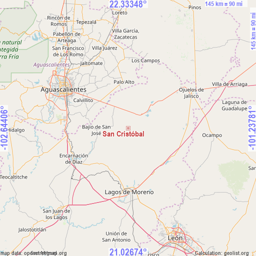
San Cristóbal GPS coordinates[2]
21° 40' 53.724" North, 101° 56' 27.348" West
| Map corner | latitude | longitude |
|---|---|---|
| Upper-left | 22.33348°, | -102.64406° |
| Center: | 21.68159°, | -101.94093° |
| Lower-right: | 21.02674°, | -101.23781° |
| Map W x H: | 145.3×145.3 km | = 90.3×90.3mi |
| max Lat: | 32.7° ⇑17.7% North |
| San Cristóbal: | 21.68159° |
| min Lat: | ⇓82.3% South 14.53588° |
| min Long | San Cristóbal | max Long |
| -117.105° | -101.94093° | -86.73105° |
| W 19.4%⇐ | ⇒80.6% E |
Elevation
Elevation of San Cristóbal is 2019 m = 6624 ft, and this is 765.3 m = 2511 ft above average elevation for this country.
| Max E: |
3497 m = 11473 ft | 25.6% |
| San Cristóbal | 2019 m 6624 ft | |
| Avg. | 1253.7 m = 4113 ft | |
Min E: |
-1 m = -3 ft | 74.4% |
See also: Mexico elevation on elevation.city.
Geographical zone
San Cristóbal is located in North Torrid zone (between Equator and Tropic of Cancer). Distance of this Northern Tropic circle is 195.2 km =121.3 mi to North.| Distance of | km | miles | from San Cristóbal |
|---|---|---|---|
| North Pole | 7596.3 | 4720.1 | to North |
| Arctic Circle | 4990.4 | 3100.9 | to North |
| Tropic Cancer | 195.2 | 121.3 | to North |
| Equator | 2410.8 | 1498 | to South |


Nearby cities:
15 places around San Cristóbal: (largest is in red/bold)
• Bajío de San José
18.1 km =11.2 mi,  267°
267°
• Betulia
11.9 km =7.4 mi,  316°
316°
• Chinampas
21.6 km =13.4 mi,  36°
36°
• Cuautitlán
6.8 km =4.2 mi,  334°
334°
• El Puesto
6.8 km =4.2 mi,  201°
201°
• El Tecuán
8.4 km =5.2 mi, 270°
• Francisco Primo de Verdad (Ciénega de Mata)
13.8 km =8.6 mi,  59°
59°
• La Presa
16.7 km =10.4 mi,  51°
51°
• La Punta
14.5 km =9 mi,  359°
359°
• La Troje
6.8 km =4.2 mi,  34°
34°
• Las Güeras
18 km =11.2 mi,  283°
283°
• Los Azulitos
18.5 km =11.5 mi,  352°
352°
• Matamoros los Hoyos
19.1 km =11.9 mi, 333°
• San Antonio de Buenavista
21.7 km =13.5 mi,  162°
162°
• Tacubaya
11 km =6.8 mi, 348°
Sources, notices
• [Note1] Compared only with cities in Mexico existing in our database
• [Src1] Map data: © OpenStreetMap contributors (CC-BY-SA)
• [Src2] Other city data from geonames.org with taken over terms of usage.
• [Src3] Geographical zone / Annual Mean Temperature by Robert A. Rohde @ Wikipedia
