Yécora geodata
Yécora (Chihuahua) is a populated place; located in Mexico in America/Hermosillo (GMT-7) time zone. With population of 2,920 people, there are 3051 cities with bigger population in this country. Compared to other cities in Mexico, 97.7% of cities are located further ↓South; 96.8% of cities are located further →East and 53.3% of cities have lower elevation than Yécora. Note1


Yécora GPS coordinates[2]
28° 22' 17.544" North, 108° 55' 40.116" West
| Map corner | latitude | longitude |
|---|---|---|
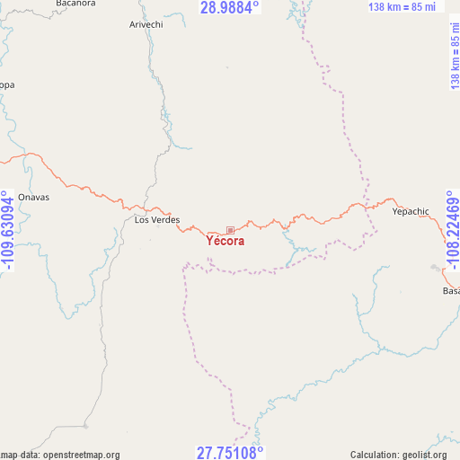
| Upper-left | 28.9884°, | -109.63094° |
| Center: | 28.37154°, | -108.92781° |
| Lower-right: | 27.75108°, | -108.22469° |
| Map W x H: | 137.6×137.6 km | = 85.5×85.5mi |
| max Lat: | 32.7° ⇑2.3% North |
| Yécora: | 28.37154° |
| min Lat: | ⇓97.7% South 14.53588° |
| min Long | Yécora | max Long |
| -117.105° | -108.92781° | -86.73105° |
| W 3.2%⇐ | ⇒96.8% E |
Elevation
Elevation of Yécora is 1546 m = 5072 ft, and this is 292.3 m = 959 ft above average elevation for this country.
| Max E: |
3497 m = 11473 ft | 46.7% |
| Yécora | 1546 m 5072 ft | |
| Avg. | 1253.7 m = 4113 ft | |
Min E: |
-1 m = -3 ft | 53.3% |
See also: Mexico elevation on elevation.city.
Geographical zone
Yécora is located in North temperate zone (between Tropic of Cancer and the Arctic Circle). Distance of this Northern Tropic circle is 548.7 km =340.9 mi to South.| Distance of | km | miles | from Yécora |
|---|---|---|---|
| North Pole | 6852.4 | 4257.9 | to North |
| Arctic Circle | 4246.6 | 2638.7 | to North |
| Tropic Cancer | 548.7 | 340.9 | to South |
| Equator | 3154.6 | 1960.2 | to South |


Nearby cities:
15 places around Yécora: (largest is in red/bold)
• Arivechi
66.8 km =41.5 mi,  337°
337°
• Bacanora
82 km =51 mi,  325°
325°
• Basaseachic
72.4 km =45 mi,  104°
104°
• Cajurichic
83.2 km =51.7 mi,  111°
111°
• Maycoba
26.4 km =16.4 mi,  85°
85°
• Moris
46.7 km =29 mi,  121°
121°
• Ocampo
58.3 km =36.2 mi, 109°
• Onavas
59.7 km =37.1 mi,  279°
279°
• Rosario
73.1 km =45.4 mi,  216°
216°
• Sahuaripa
81.6 km =50.7 mi, 338°
• San Javier
83.2 km =51.7 mi,  287°
287°
• Soyopa
81.7 km =50.8 mi,  302°
302°
• Suaqui Grande
94 km =58.4 mi,  271°
271°
• Uruachi
89.6 km =55.7 mi,  128°
128°
• Yepachic
54.2 km =33.7 mi,  84°
84°
Sources, notices
• [Note1] Compared only with cities in Mexico existing in our database
• [Src1] Map data: © OpenStreetMap contributors (CC-BY-SA)
• [Src2] Other city data from geonames.org with taken over terms of usage.
• [Src3] Geographical zone / Annual Mean Temperature by Robert A. Rohde @ Wikipedia
