Basaseachic geodata
Basaseachic (Chihuahua) is a populated place; located in Mexico in America/Chihuahua (GMT-6) time zone. With population of 1,248 people, there are 6955 cities with bigger population in this country. Compared to other cities in Mexico, 97.5% of cities are located further ↓South; 95.8% of cities are located further →East and 73.5% of cities have lower elevation than Basaseachic. Note1


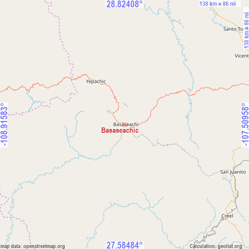
Basaseachic GPS coordinates[2]
28° 12' 22.536" North, 108° 12' 45.72" West
| Map corner | latitude | longitude |
|---|---|---|
| Upper-left | 28.82408°, | -108.91583° |
| Center: | 28.20626°, | -108.2127° |
| Lower-right: | 27.58484°, | -107.50958° |
| Map W x H: | 137.8×137.8 km | = 85.6×85.6mi |
| max Lat: | 32.7° ⇑2.5% North |
| Basaseachic: | 28.20626° |
| min Lat: | ⇓97.5% South 14.53588° |
| min Long | Basaseachic | max Long |
| -117.105° | -108.2127° | -86.73105° |
| W 4.2%⇐ | ⇒95.8% E |
Elevation
Elevation of Basaseachic is 2000 m = 6562 ft, and this is 746.3 m = 2448 ft above average elevation for this country.
| Max E: |
3497 m = 11473 ft | 26.5% |
| Basaseachic | 2000 m 6562 ft | |
| Avg. | 1253.7 m = 4113 ft | |
Min E: |
-1 m = -3 ft | 73.5% |
See also: Mexico elevation on elevation.city.
Geographical zone
Basaseachic is located in North temperate zone (between Tropic of Cancer and the Arctic Circle). Distance of this Northern Tropic circle is 530.3 km =329.5 mi to South.| Distance of | km | miles | from Basaseachic |
|---|---|---|---|
| North Pole | 6870.8 | 4269.3 | to North |
| Arctic Circle | 4264.9 | 2650.1 | to North |
| Tropic Cancer | 530.3 | 329.5 | to South |
| Equator | 3136.2 | 1948.7 | to South |


Nearby cities:
15 places around Basaseachic: (largest is in red/bold)
• Bocoyna
73.4 km =45.6 mi,  123°
123°
• Cajurichic
14 km =8.7 mi,  147°
147°
• Creel
76 km =47.2 mi,  131°
131°
• Guerrero
80.8 km =50.2 mi,  61°
61°
• Maguarichi
44.2 km =27.5 mi, 150°
• Maycoba
48.4 km =30.1 mi,  295°
295°
• Moris
31.1 km =19.3 mi,  258°
258°
• Ocampo
15.2 km =9.4 mi, 264°
• Pachera
80.1 km =49.8 mi,  83°
83°
• San Juanito
65.3 km =40.6 mi,  113°
113°
• Tacuba
74.2 km =46.1 mi, 77°
• Tomochic
39.4 km =24.5 mi,  65°
65°
• Uruachi
37.7 km =23.4 mi,  180°
180°
• Yepachic
28.8 km =17.9 mi,  326°
326°
• Yécora
72.4 km =45 mi,  284°
284°
Sources, notices
• [Note1] Compared only with cities in Mexico existing in our database
• [Src1] Map data: © OpenStreetMap contributors (CC-BY-SA)
• [Src2] Other city data from geonames.org with taken over terms of usage.
• [Src3] Geographical zone / Annual Mean Temperature by Robert A. Rohde @ Wikipedia
