Arivechi geodata
Arivechi (Sonora) is a seat of a second-order administrative division; located in Mexico in America/Hermosillo (GMT-7) time zone. With population of 743 people, there are 11779 cities with bigger population in this country. Compared to other cities in Mexico, 98% of cities are located further ↓South; 97.2% of cities are located further →East and 68.5% of cities have higher elevation than Arivechi. Note1


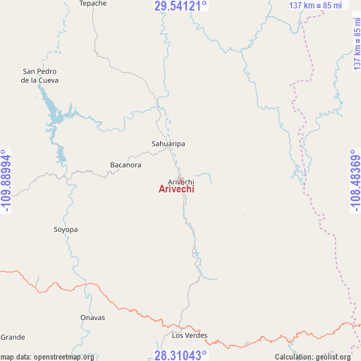
Arivechi GPS coordinates[2]
28° 55' 39.54" North, 109° 11' 12.516" West
| Map corner | latitude | longitude |
|---|---|---|
| Upper-left | 29.54121°, | -109.88994° |
| Center: | 28.92765°, | -109.18681° |
| Lower-right: | 28.31043°, | -108.48369° |
| Map W x H: | 136.8×136.9 km | = 85×85.1mi |
| max Lat: | 32.7° ⇑2% North |
| Arivechi: | 28.92765° |
| min Lat: | ⇓98% South 14.53588° |
| min Long | Arivechi | max Long |
| -117.105° | -109.18681° | -86.73105° |
| W 2.8%⇐ | ⇒97.2% E |
Elevation
Elevation of Arivechi is 497 m = 1631 ft, and this is 756.7 m = 2483 ft below average elevation for this country.
| Max E: |
3497 m = 11473 ft | 68.5% |
| Avg. | 1253.7 m = 4113 ft | |
| Arivechi | 497 m = 1631 ft | |
Min E: |
-1 m = -3 ft | 31.5% |
See also: Mexico elevation on elevation.city.
Geographical zone
Arivechi is located in North temperate zone (between Tropic of Cancer and the Arctic Circle). Distance of this Northern Tropic circle is 610.5 km =379.3 mi to South.| Distance of | km | miles | from Arivechi |
|---|---|---|---|
| North Pole | 6790.6 | 4219.5 | to North |
| Arctic Circle | 4184.7 | 2600.3 | to North |
| Tropic Cancer | 610.5 | 379.3 | to South |
| Equator | 3216.5 | 1998.6 | to South |


Nearby cities:
15 places around Arivechi: (largest is in red/bold)
• Bacanora
21.6 km =13.4 mi,  286°
286°
• Divisaderos
81.2 km =50.5 mi,  340°
340°
• Maycoba
78.7 km =48.9 mi,  139°
139°
• Mazatán
92.9 km =57.7 mi,  275°
275°
• Nácori Chico
86.8 km =53.9 mi,  13°
13°
• Onavas
61.8 km =38.4 mi,  212°
212°
• Sahuaripa
14.8 km =9.2 mi, 341°
• San Javier
65.3 km =40.6 mi,  235°
235°
• San Pedro de la Cueva
66.7 km =41.4 mi,  306°
306°
• Soyopa
47.2 km =29.3 mi,  247°
247°
• Suaqui Grande
90.6 km =56.3 mi,  229°
229°
• Tecoripa
82.1 km =51 mi, 245°
• Tepache
75.1 km =46.7 mi,  333°
333°
• Villa Pesqueira
78.8 km =49 mi, 285°
• Yécora
66.8 km =41.5 mi,  157°
157°
Sources, notices
• [Note1] Compared only with cities in Mexico existing in our database
• [Src1] Map data: © OpenStreetMap contributors (CC-BY-SA)
• [Src2] Other city data from geonames.org with taken over terms of usage.
• [Src3] Geographical zone / Annual Mean Temperature by Robert A. Rohde @ Wikipedia
