Batuecas geodata
Batuecas (State of Mexico) is a populated place; located in Mexico in America/Mexico_City (GMT-6) time zone. With population of 663 people, there are 13102 cities with bigger population in this country. Compared to other cities in Mexico, 57.9% of cities are located further ↓South; 77.2% of cities are located further →East and 80.6% of cities have lower elevation than Batuecas. Note1


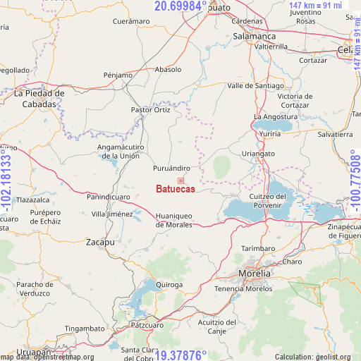
Batuecas GPS coordinates[2]
20° 2' 26.484" North, 101° 28' 41.52" West
| Map corner | latitude | longitude |
|---|---|---|
| Upper-left | 20.69984°, | -102.18133° |
| Center: | 20.04069°, | -101.4782° |
| Lower-right: | 19.37876°, | -100.77508° |
| Map W x H: | 146.9×146.9 km | = 91.3×91.3mi |
| max Lat: | 32.7° ⇑42.1% North |
| Batuecas: | 20.04069° |
| min Lat: | ⇓57.9% South 14.53588° |
| min Long | Batuecas | max Long |
| -117.105° | -101.4782° | -86.73105° |
| W 22.8%⇐ | ⇒77.2% E |
Elevation
Elevation of Batuecas is 2155 m = 7070 ft, and this is 901.3 m = 2957 ft above average elevation for this country.
| Max E: |
3497 m = 11473 ft | 19.4% |
| Batuecas | 2155 m 7070 ft | |
| Avg. | 1253.7 m = 4113 ft | |
Min E: |
-1 m = -3 ft | 80.6% |
See also: Mexico elevation on elevation.city.
Geographical zone
Batuecas is located in North Torrid zone (between Equator and Tropic of Cancer). Distance of this Northern Tropic circle is 377.6 km =234.6 mi to North.| Distance of | km | miles | from Batuecas |
|---|---|---|---|
| North Pole | 7778.7 | 4833.5 | to North |
| Arctic Circle | 5172.9 | 3214.3 | to North |
| Tropic Cancer | 377.6 | 234.6 | to North |
| Equator | 2228.3 | 1384.6 | to South |


Nearby cities:
15 places around Batuecas: (largest is in red/bold)
• Cerano
12.2 km =7.6 mi,  51°
51°
• Cerécuaro
13.9 km =8.6 mi,  85°
85°
• Galeana
9.8 km =6.1 mi,  266°
266°
• Huatajo
15.3 km =9.5 mi,  1°
1°
• Janamuato
13 km =8.1 mi,  300°
300°
• La Barranca
5.7 km =3.5 mi,  40°
40°
• La Excusa
11.5 km =7.1 mi,  352°
352°
• Las Tortugas (Emiliano Zapata)
13 km =8.1 mi,  31°
31°
• Ojos de Agua de Cerano
13.9 km =8.6 mi,  56°
56°
• Puruándiro
6.6 km =4.1 mi,  323°
323°
• Sabino Buenavista
12.2 km =7.6 mi,  289°
289°
• San Nicolás Tumbastatiro (Cañada de Abajo)
15 km =9.3 mi,  109°
109°
• San Pedro (San Pedro Carano)
10.5 km =6.5 mi,  339°
339°
• Ururuta
13.5 km =8.4 mi, 271°
• Villa Morelos
7.9 km =4.9 mi,  121°
121°
Sources, notices
• [Note1] Compared only with cities in Mexico existing in our database
• [Src1] Map data: © OpenStreetMap contributors (CC-BY-SA)
• [Src2] Other city data from geonames.org with taken over terms of usage.
• [Src3] Geographical zone / Annual Mean Temperature by Robert A. Rohde @ Wikipedia
