Cofradía de Suchitlán geodata
Cofradía de Suchitlán (Colima) is a populated place; located in Mexico in America/Mexico_City (GMT-6) time zone. With population of 1,746 people, there are 4971 cities with bigger population in this country. Compared to other cities in Mexico, 56.1% of cities are located further ↑North; 89% of cities are located further →East and 52.9% of cities have higher elevation than Cofradía de Suchitlán. Note1
Current local time in Cofradía de Suchitlán:
05:36 AM, WednesdayDifference from your time zone: hours


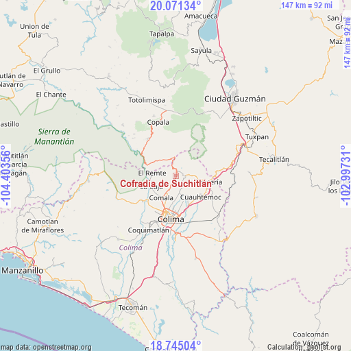
Cofradía de Suchitlán GPS coordinates[2]
19° 24' 34.344" North, 103° 42' 1.548" West
| Map corner | latitude | longitude |
|---|---|---|
| Upper-left | 20.07134°, | -104.40356° |
| Center: | 19.40954°, | -103.70043° |
| Lower-right: | 18.74504°, | -102.99731° |
| Map W x H: | 147.5×147.5 km | = 91.7×91.7mi |
| max Lat: | 32.7° ⇑56.1% North |
| Cofradía de Suchitlán: | 19.40954° |
| min Lat: | ⇓43.9% South 14.53588° |
| min Long | Cofradía de Su | max Long |
| -117.105° | -103.70043° | -86.73105° |
| W 11%⇐ | ⇒89% E |
Elevation
Elevation of Cofradía de Suchitlán is 1295 m = 4249 ft, and this is 41.3 m = 135 ft above average elevation for this country.
| Max E: |
3497 m = 11473 ft | 52.9% |
| Cofradía de Suchitlán | 1295 m 4249 ft | |
| Avg. | 1253.7 m = 4113 ft | |
Min E: |
-1 m = -3 ft | 47.1% |
See also: Mexico elevation on elevation.city.
Geographical zone
Cofradía de Suchitlán is located in North Torrid zone (between Equator and Tropic of Cancer). Distance of this Northern Tropic circle is 447.8 km =278.2 mi to North.| Distance of | km | miles | from Cofradía de Suchitlán |
|---|---|---|---|
| North Pole | 7848.9 | 4877.1 | to North |
| Arctic Circle | 5243 | 3257.8 | to North |
| Tropic Cancer | 447.8 | 278.2 | to North |
| Equator | 2158.1 | 1341 | to South |


Nearby cities:
15 places around Cofradía de Suchitlán: (largest is in red/bold)
• Alcaraces
13.9 km =8.6 mi,  111°
111°
• Chiapa
9.4 km =5.8 mi,  148°
148°
• Ciudad de Villa de Álvarez
16.3 km =10.1 mi,  193°
193°
• Cofradía
16 km =9.9 mi,  80°
80°
• Comala
11 km =6.8 mi,  213°
213°
• Cuauhtémoc
13.6 km =8.5 mi,  131°
131°
• El Chanal
12.8 km =8 mi,  182°
182°
• El Trapiche
15.2 km =9.4 mi,  164°
164°
• La Caja
11.2 km =7 mi,  247°
247°
• Ocotillo
10 km =6.2 mi, 148°
• Palmillas
16.9 km =10.5 mi, 112°
• Quesería
13.7 km =8.5 mi,  100°
100°
• San José del Carmen
9.1 km =5.7 mi,  311°
311°
• Suchitlán
4 km =2.5 mi,  196°
196°
• Zacualpan
14 km =8.7 mi, 248°
Sources, notices
• [Note1] Compared only with cities in Mexico existing in our database
• [Src1] Map data: © OpenStreetMap contributors (CC-BY-SA)
• [Src2] Other city data from geonames.org with taken over terms of usage.
• [Src3] Geographical zone / Annual Mean Temperature by Robert A. Rohde @ Wikipedia
