Tonila geodata
Tonila (Jalisco) is a populated place; located in Mexico in America/Mexico_City (GMT-6) time zone. With population of 3,345 people, there are 2718 cities with bigger population in this country. Compared to other cities in Mexico, 55.4% of cities are located further ↑North; 88.4% of cities are located further →East and 56% of cities have higher elevation than Tonila. Note1


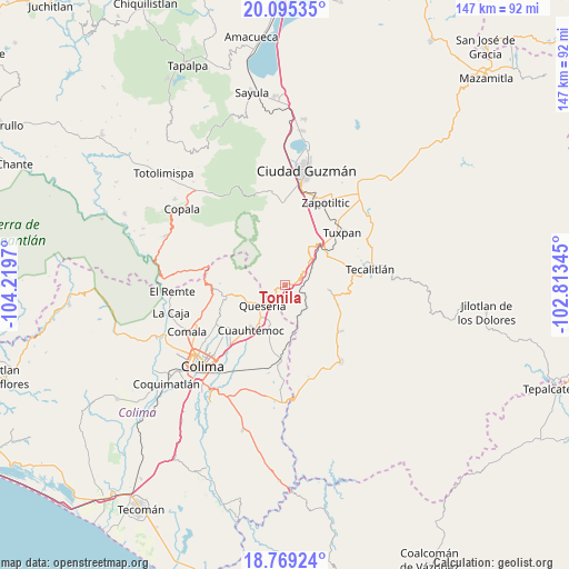
Tonila GPS coordinates[2]
19° 26' 1.14" North, 103° 30' 59.652" West
| Map corner | latitude | longitude |
|---|---|---|
| Upper-left | 20.09535°, | -104.2197° |
| Center: | 19.43365°, | -103.51657° |
| Lower-right: | 18.76924°, | -102.81345° |
| Map W x H: | 147.4×147.5 km | = 91.6×91.7mi |
| max Lat: | 32.7° ⇑55.4% North |
| Tonila: | 19.43365° |
| min Lat: | ⇓44.6% South 14.53588° |
| min Long | Tonila | max Long |
| -117.105° | -103.51657° | -86.73105° |
| W 11.6%⇐ | ⇒88.4% E |
Elevation
Elevation of Tonila is 1161 m = 3809 ft, and this is 92.7 m = 304 ft below average elevation for this country.
| Max E: |
3497 m = 11473 ft | 56% |
| Avg. | 1253.7 m = 4113 ft | |
| Tonila | 1161 m = 3809 ft | |
Min E: |
-1 m = -3 ft | 44% |
See also: Mexico elevation on elevation.city.
Geographical zone
Tonila is located in North Torrid zone (between Equator and Tropic of Cancer). Distance of this Northern Tropic circle is 445.1 km =276.6 mi to North.| Distance of | km | miles | from Tonila |
|---|---|---|---|
| North Pole | 7846.2 | 4875.4 | to North |
| Arctic Circle | 5240.4 | 3256.2 | to North |
| Tropic Cancer | 445.1 | 276.6 | to North |
| Equator | 2160.8 | 1342.7 | to South |


Nearby cities:
15 places around Tonila: (largest is in red/bold)
• Alcaraces
10 km =6.2 mi,  219°
219°
• Alzada
19.6 km =12.2 mi,  184°
184°
• Atenquique
13.3 km =8.3 mi,  36°
36°
• Chiapa
18 km =11.2 mi,  233°
233°
• Cofradía
3.5 km =2.2 mi,  269°
269°
• Cofradía de Suchitlán
19.5 km =12.1 mi,  262°
262°
• Cuauhtémoc
14.8 km =9.2 mi, 217°
• El Pozo Santo (Crucero del Tule)
18.2 km =11.3 mi,  131°
131°
• La Higuera
11.3 km =7 mi,  95°
95°
• Ocotillo
17.9 km =11.1 mi, 231°
• Palmillas
9.8 km =6.1 mi,  201°
201°
• Quesería
7.8 km =4.8 mi, 228°
• San Juan Espanatica
13.9 km =8.6 mi,  59°
59°
• San Marcos
1.7 km =1.1 mi, 37°
• Tuxpan
20 km =12.4 mi,  47°
47°
Sources, notices
• [Note1] Compared only with cities in Mexico existing in our database
• [Src1] Map data: © OpenStreetMap contributors (CC-BY-SA)
• [Src2] Other city data from geonames.org with taken over terms of usage.
• [Src3] Geographical zone / Annual Mean Temperature by Robert A. Rohde @ Wikipedia
