Cofradía geodata
Cofradía (Colima) is a populated place; located in Mexico in America/Mexico_City (GMT-6) time zone. With population of 6,495 people, there are 1446 cities with bigger population in this country. Compared to other cities in Mexico, 55.4% of cities are located further ↑North; 88.5% of cities are located further →East and 50.7% of cities have higher elevation than Cofradía. Note1


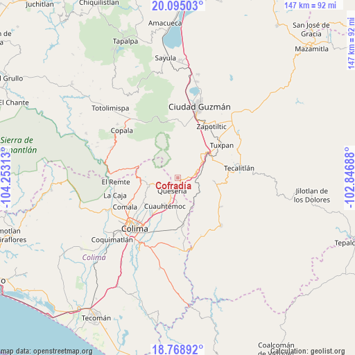
Cofradía GPS coordinates[2]
19° 25' 59.988" North, 103° 33' 0" West
| Map corner | latitude | longitude |
|---|---|---|
| Upper-left | 20.09503°, | -104.25313° |
| Center: | 19.43333°, | -103.55° |
| Lower-right: | 18.76892°, | -102.84688° |
| Map W x H: | 147.4×147.5 km | = 91.6×91.7mi |
| max Lat: | 32.7° ⇑55.4% North |
| Cofradía: | 19.43333° |
| min Lat: | ⇓44.6% South 14.53588° |
| min Long | Cofradía | max Long |
| -117.105° | -103.55° | -86.73105° |
| W 11.5%⇐ | ⇒88.5% E |
Elevation
Elevation of Cofradía is 1394 m = 4573 ft, and this is 140.3 m = 460 ft above average elevation for this country.
| Max E: |
3497 m = 11473 ft | 50.7% |
| Cofradía | 1394 m 4573 ft | |
| Avg. | 1253.7 m = 4113 ft | |
Min E: |
-1 m = -3 ft | 49.3% |
See also: Mexico elevation on elevation.city.
Geographical zone
Cofradía is located in North Torrid zone (between Equator and Tropic of Cancer). Distance of this Northern Tropic circle is 445.1 km =276.6 mi to North.| Distance of | km | miles | from Cofradía |
|---|---|---|---|
| North Pole | 7846.3 | 4875.5 | to North |
| Arctic Circle | 5240.4 | 3256.2 | to North |
| Tropic Cancer | 445.1 | 276.6 | to North |
| Equator | 2160.8 | 1342.7 | to South |


Nearby cities:
15 places around Cofradía: (largest is in red/bold)
• Alcaraces
8.2 km =5.1 mi,  200°
200°
• Alzada
19.6 km =12.2 mi,  173°
173°
• Atenquique
15.6 km =9.7 mi,  46°
46°
• Chiapa
15.3 km =9.5 mi,  225°
225°
• Cofradía de Suchitlán
16 km =9.9 mi,  260°
260°
• Cuauhtémoc
12.9 km =8 mi,  205°
205°
• El Trapiche
20.8 km =12.9 mi, 213°
• La Higuera
14.8 km =9.2 mi,  94°
94°
• Ocotillo
15.3 km =9.5 mi,  223°
223°
• Palmillas
9.1 km =5.7 mi,  180°
180°
• Quesería
5.7 km =3.5 mi, 204°
• San Juan Espanatica
17.1 km =10.6 mi,  65°
65°
• San Marcos
4.8 km =3 mi, 72°
• Suchitlán
18.1 km =11.2 mi,  249°
249°
• Tonila
3.5 km =2.2 mi, 89°
Sources, notices
• [Note1] Compared only with cities in Mexico existing in our database
• [Src1] Map data: © OpenStreetMap contributors (CC-BY-SA)
• [Src2] Other city data from geonames.org with taken over terms of usage.
• [Src3] Geographical zone / Annual Mean Temperature by Robert A. Rohde @ Wikipedia
