Alzada geodata
Alzada (Colima) is a populated place; located in Mexico in America/Mexico_City (GMT-6) time zone. With population of 533 people, there are 15888 cities with bigger population in this country. Compared to other cities in Mexico, 59.7% of cities are located further ↑North; 88.4% of cities are located further →East and 65.4% of cities have higher elevation than Alzada. Note1


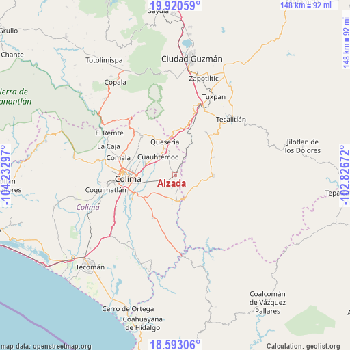
Alzada GPS coordinates[2]
19° 15' 29.412" North, 103° 31' 47.424" West
| Map corner | latitude | longitude |
|---|---|---|
| Upper-left | 19.92059°, | -104.23297° |
| Center: | 19.25817°, | -103.52984° |
| Lower-right: | 18.59306°, | -102.82672° |
| Map W x H: | 147.6×147.6 km | = 91.7×91.7mi |
| max Lat: | 32.7° ⇑59.7% North |
| Alzada: | 19.25817° |
| min Lat: | ⇓40.3% South 14.53588° |
| min Long | Alzada | max Long |
| -117.105° | -103.52984° | -86.73105° |
| W 11.6%⇐ | ⇒88.4% E |
Elevation
Elevation of Alzada is 666 m = 2185 ft, and this is 587.7 m = 1928 ft below average elevation for this country.
| Max E: |
3497 m = 11473 ft | 65.4% |
| Avg. | 1253.7 m = 4113 ft | |
| Alzada | 666 m = 2185 ft | |
Min E: |
-1 m = -3 ft | 34.6% |
See also: Mexico elevation on elevation.city.
Geographical zone
Alzada is located in North Torrid zone (between Equator and Tropic of Cancer). Distance of this Northern Tropic circle is 464.6 km =288.7 mi to North.| Distance of | km | miles | from Alzada |
|---|---|---|---|
| North Pole | 7865.8 | 4887.6 | to North |
| Arctic Circle | 5259.9 | 3268.3 | to North |
| Tropic Cancer | 464.6 | 288.7 | to North |
| Equator | 2141.3 | 1330.5 | to South |


Nearby cities:
15 places around Alzada: (largest is in red/bold)
• Alcaraces
12.8 km =8 mi,  337°
337°
• Buenavista
8.6 km =5.3 mi,  264°
264°
• Chiapa
15.7 km =9.8 mi,  303°
303°
• Cofradía
19.6 km =12.2 mi,  353°
353°
• Cuauhtémoc
11 km =6.8 mi,  315°
315°
• El Chanal
18.9 km =11.7 mi,  282°
282°
• El Pozo Santo (Crucero del Tule)
16.9 km =10.5 mi,  63°
63°
• El Trapiche
13.9 km =8.6 mi, 279°
• La Estrella
8.5 km =5.3 mi,  119°
119°
• Los Tepames
20.7 km =12.9 mi,  208°
208°
• Ocotillo
15.1 km =9.4 mi, 303°
• Palmillas
10.7 km =6.6 mi, 347°
• Pihuamo
15.5 km =9.6 mi,  93°
93°
• Quesería
15 km =9.3 mi, 342°
• Tonila
19.6 km =12.2 mi,  4°
4°
Sources, notices
• [Note1] Compared only with cities in Mexico existing in our database
• [Src1] Map data: © OpenStreetMap contributors (CC-BY-SA)
• [Src2] Other city data from geonames.org with taken over terms of usage.
• [Src3] Geographical zone / Annual Mean Temperature by Robert A. Rohde @ Wikipedia
