Quesería geodata
Quesería (Colima) is a populated place; located in Mexico in America/Mexico_City (GMT-6) time zone. With population of 8,611 people, there are 1107 cities with bigger population in this country. Compared to other cities in Mexico, 56.6% of cities are located further ↑North; 88.6% of cities are located further →East and 53.8% of cities have higher elevation than Quesería. Note1


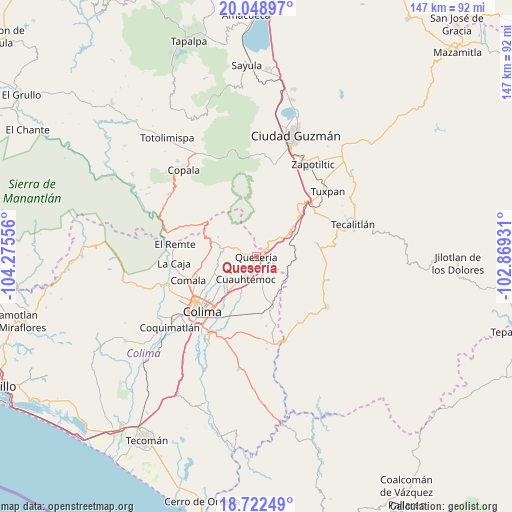
Quesería GPS coordinates[2]
19° 23' 13.488" North, 103° 34' 20.748" West
| Map corner | latitude | longitude |
|---|---|---|
| Upper-left | 20.04897°, | -104.27556° |
| Center: | 19.38708°, | -103.57243° |
| Lower-right: | 18.72249°, | -102.86931° |
| Map W x H: | 147.5×147.5 km | = 91.7×91.7mi |
| max Lat: | 32.7° ⇑56.6% North |
| Quesería: | 19.38708° |
| min Lat: | ⇓43.4% South 14.53588° |
| min Long | Quesería | max Long |
| -117.105° | -103.57243° | -86.73105° |
| W 11.4%⇐ | ⇒88.6% E |
Elevation
Elevation of Quesería is 1255 m = 4117 ft, and this is 1.3 m = 4 ft above average elevation for this country.
| Max E: |
3497 m = 11473 ft | 53.8% |
| Quesería | 1255 m 4117 ft | |
| Avg. | 1253.7 m = 4113 ft | |
Min E: |
-1 m = -3 ft | 46.2% |
See also: Mexico elevation on elevation.city.
Geographical zone
Quesería is located in North Torrid zone (between Equator and Tropic of Cancer). Distance of this Northern Tropic circle is 450.3 km =279.8 mi to North.| Distance of | km | miles | from Quesería |
|---|---|---|---|
| North Pole | 7851.4 | 4878.6 | to North |
| Arctic Circle | 5245.5 | 3259.4 | to North |
| Tropic Cancer | 450.3 | 279.8 | to North |
| Equator | 2155.6 | 1339.4 | to South |


Nearby cities:
15 places around Quesería: (largest is in red/bold)
• Alcaraces
2.6 km =1.6 mi,  190°
190°
• Alzada
15 km =9.3 mi,  162°
162°
• Buenavista
15.7 km =9.8 mi, 194°
• Chiapa
10.2 km =6.3 mi,  236°
236°
• Cofradía
5.7 km =3.5 mi,  24°
24°
• Cofradía de Suchitlán
13.7 km =8.5 mi,  280°
280°
• Cuauhtémoc
7.2 km =4.5 mi,  206°
206°
• El Chanal
17.4 km =10.8 mi,  233°
233°
• El Trapiche
15.3 km =9.5 mi,  217°
217°
• La Higuera
17.5 km =10.9 mi,  76°
76°
• Ocotillo
10.1 km =6.3 mi, 233°
• Palmillas
4.5 km =2.8 mi,  150°
150°
• San Marcos
9.5 km =5.9 mi,  46°
46°
• Suchitlán
14.6 km =9.1 mi,  264°
264°
• Tonila
7.8 km =4.8 mi, 48°
Sources, notices
• [Note1] Compared only with cities in Mexico existing in our database
• [Src1] Map data: © OpenStreetMap contributors (CC-BY-SA)
• [Src2] Other city data from geonames.org with taken over terms of usage.
• [Src3] Geographical zone / Annual Mean Temperature by Robert A. Rohde @ Wikipedia
