Tecolotlán geodata
Tecolotlán (Jalisco) is a seat of a second-order administrative division; located in Mexico in America/Mexico_City (GMT-6) time zone. With population of 9,189 people, there are 1026 cities with bigger population in this country. Compared to other cities in Mexico, 61.4% of cities are located further ↓South; 90.1% of cities are located further →East and 54.8% of cities have higher elevation than Tecolotlán. Note1


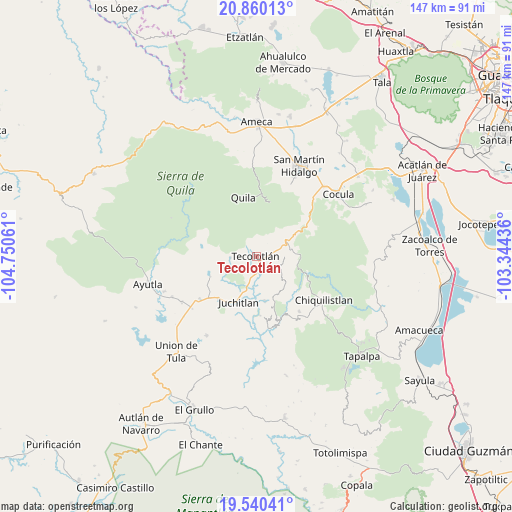
Tecolotlán GPS coordinates[2]
20° 12' 6.012" North, 104° 2' 50.928" West
| Map corner | latitude | longitude |
|---|---|---|
| Upper-left | 20.86013°, | -104.75061° |
| Center: | 20.20167°, | -104.04748° |
| Lower-right: | 19.54041°, | -103.34436° |
| Map W x H: | 146.7×146.7 km | = 91.2×91.2mi |
| max Lat: | 32.7° ⇑38.6% North |
| Tecolotlán: | 20.20167° |
| min Lat: | ⇓61.4% South 14.53588° |
| min Long | Tecolotlán | max Long |
| -117.105° | -104.04748° | -86.73105° |
| W 9.9%⇐ | ⇒90.1% E |
Elevation
Elevation of Tecolotlán is 1207 m = 3960 ft, and this is 46.7 m = 153 ft below average elevation for this country.
| Max E: |
3497 m = 11473 ft | 54.8% |
| Avg. | 1253.7 m = 4113 ft | |
| Tecolotlán | 1207 m = 3960 ft | |
Min E: |
-1 m = -3 ft | 45.2% |
See also: Mexico elevation on elevation.city.
Geographical zone
Tecolotlán is located in North Torrid zone (between Equator and Tropic of Cancer). Distance of this Northern Tropic circle is 359.7 km =223.5 mi to North.| Distance of | km | miles | from Tecolotlán |
|---|---|---|---|
| North Pole | 7760.8 | 4822.3 | to North |
| Arctic Circle | 5155 | 3203.2 | to North |
| Tropic Cancer | 359.7 | 223.5 | to North |
| Equator | 2246.2 | 1395.7 | to South |


Nearby cities:
15 places around Tecolotlán: (largest is in red/bold)
• Atengo
21.4 km =13.3 mi,  292°
292°
• Ayotitlán
11 km =6.8 mi,  79°
79°
• Chiquilistlán
23.2 km =14.4 mi,  123°
123°
• Chiquilistlán
24.1 km =15 mi,  90°
90°
• Cofradía de Duendes
5.7 km =3.5 mi,  51°
51°
• Colotitlán
16.2 km =10.1 mi,  223°
223°
• Ipazoltic
26.7 km =16.6 mi,  13°
13°
• Juanacatlán
21.6 km =13.4 mi,  266°
266°
• Juchitlán
14 km =8.7 mi,  202°
202°
• Los Guajes
13.1 km =8.1 mi,  169°
169°
• San Clemente
25 km =15.5 mi,  238°
238°
• Santa Cruz de las Flores
23.8 km =14.8 mi,  25°
25°
• Soyatlán del Oro
26.7 km =16.6 mi, 294°
• Tamazulita
8.2 km =5.1 mi, 87°
• Tenamaxtlán
12.3 km =7.6 mi,  278°
278°
Sources, notices
• [Note1] Compared only with cities in Mexico existing in our database
• [Src1] Map data: © OpenStreetMap contributors (CC-BY-SA)
• [Src2] Other city data from geonames.org with taken over terms of usage.
• [Src3] Geographical zone / Annual Mean Temperature by Robert A. Rohde @ Wikipedia
