Ayotitlán geodata
Ayotitlán (Jalisco) is a populated place; located in Mexico in America/Mexico_City (GMT-6) time zone. With population of 1,218 people, there are 7137 cities with bigger population in this country. Compared to other cities in Mexico, 61.8% of cities are located further ↓South; 89.8% of cities are located further →East and 53.4% of cities have higher elevation than Ayotitlán. Note1


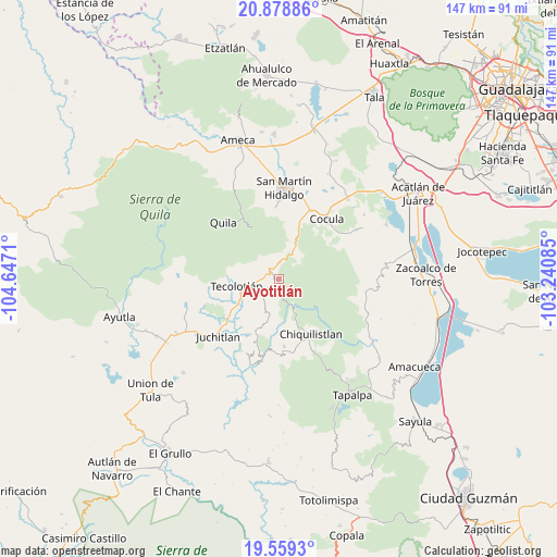
Ayotitlán GPS coordinates[2]
20° 13' 13.728" North, 103° 56' 38.292" West
| Map corner | latitude | longitude |
|---|---|---|
| Upper-left | 20.87886°, | -104.6471° |
| Center: | 20.22048°, | -103.94397° |
| Lower-right: | 19.5593°, | -103.24085° |
| Map W x H: | 146.7×146.7 km | = 91.2×91.2mi |
| max Lat: | 32.7° ⇑38.2% North |
| Ayotitlán: | 20.22048° |
| min Lat: | ⇓61.8% South 14.53588° |
| min Long | Ayotitlán | max Long |
| -117.105° | -103.94397° | -86.73105° |
| W 10.2%⇐ | ⇒89.8% E |
Elevation
Elevation of Ayotitlán is 1273 m = 4177 ft, and this is 19.3 m = 63 ft above average elevation for this country.
| Max E: |
3497 m = 11473 ft | 53.4% |
| Ayotitlán | 1273 m 4177 ft | |
| Avg. | 1253.7 m = 4113 ft | |
Min E: |
-1 m = -3 ft | 46.6% |
See also: Mexico elevation on elevation.city.
Geographical zone
Ayotitlán is located in North Torrid zone (between Equator and Tropic of Cancer). Distance of this Northern Tropic circle is 357.6 km =222.2 mi to North.| Distance of | km | miles | from Ayotitlán |
|---|---|---|---|
| North Pole | 7758.8 | 4821.1 | to North |
| Arctic Circle | 5152.9 | 3201.9 | to North |
| Tropic Cancer | 357.6 | 222.2 | to North |
| Equator | 2248.3 | 1397 | to South |


Nearby cities:
15 places around Ayotitlán: (largest is in red/bold)
• Buenavista
24.1 km =15 mi,  57°
57°
• Chiquilistlán
13.5 km =8.4 mi,  99°
99°
• Chiquilistlán
17.1 km =10.6 mi,  149°
149°
• Cocula
20.5 km =12.7 mi,  38°
38°
• Cofradía de Duendes
6.5 km =4 mi,  282°
282°
• El Crucero de Santa María
20 km =12.4 mi,  25°
25°
• Juchitlán
22 km =13.7 mi,  227°
227°
• Los Guajes
17.2 km =10.7 mi,  209°
209°
• San Martín Hidalgo
23.9 km =14.9 mi,  3°
3°
• Santa Cruz de las Flores
19.3 km =12 mi,  358°
358°
• Santa María
22.2 km =13.8 mi, 25°
• Santa Teresa
20.3 km =12.6 mi, 55°
• Tamazulita
3.2 km =2 mi,  236°
236°
• Tecolotlán
11 km =6.8 mi,  259°
259°
• Tenamaxtlán
23 km =14.3 mi,  269°
269°
Sources, notices
• [Note1] Compared only with cities in Mexico existing in our database
• [Src1] Map data: © OpenStreetMap contributors (CC-BY-SA)
• [Src2] Other city data from geonames.org with taken over terms of usage.
• [Src3] Geographical zone / Annual Mean Temperature by Robert A. Rohde @ Wikipedia
