Tenamaxtlán geodata
Tenamaxtlán (Jalisco) is a seat of a second-order administrative division; located in Mexico in America/Mexico_City (GMT-6) time zone. With population of 4,711 people, there are 1960 cities with bigger population in this country. Compared to other cities in Mexico, 61.8% of cities are located further ↓South; 90.4% of cities are located further →East and 50.8% of cities have lower elevation than Tenamaxtlán. Note1


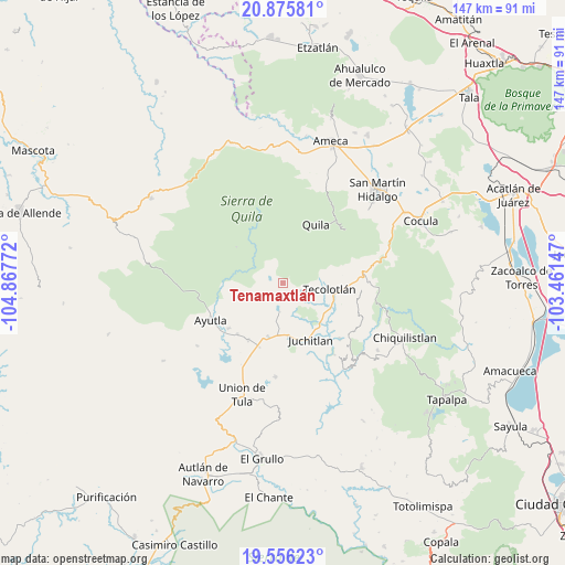
Tenamaxtlán GPS coordinates[2]
20° 13' 2.712" North, 104° 9' 52.524" West
| Map corner | latitude | longitude |
|---|---|---|
| Upper-left | 20.87581°, | -104.86772° |
| Center: | 20.21742°, | -104.16459° |
| Lower-right: | 19.55623°, | -103.46147° |
| Map W x H: | 146.7×146.7 km | = 91.2×91.2mi |
| max Lat: | 32.7° ⇑38.2% North |
| Tenamaxtlán: | 20.21742° |
| min Lat: | ⇓61.8% South 14.53588° |
| min Long | Tenamaxtlán | max Long |
| -117.105° | -104.16459° | -86.73105° |
| W 9.6%⇐ | ⇒90.4% E |
Elevation
Elevation of Tenamaxtlán is 1476 m = 4843 ft, and this is 222.3 m = 729 ft above average elevation for this country.
| Max E: |
3497 m = 11473 ft | 49.2% |
| Tenamaxtlán | 1476 m 4843 ft | |
| Avg. | 1253.7 m = 4113 ft | |
Min E: |
-1 m = -3 ft | 50.8% |
See also: Mexico elevation on elevation.city.
Geographical zone
Tenamaxtlán is located in North Torrid zone (between Equator and Tropic of Cancer). Distance of this Northern Tropic circle is 358 km =222.5 mi to North.| Distance of | km | miles | from Tenamaxtlán |
|---|---|---|---|
| North Pole | 7759.1 | 4821.3 | to North |
| Arctic Circle | 5153.2 | 3202 | to North |
| Tropic Cancer | 358 | 222.5 | to North |
| Equator | 2248 | 1396.8 | to South |


Nearby cities:
15 places around Tenamaxtlán: (largest is in red/bold)
• Atengo
9.9 km =6.2 mi,  309°
309°
• Ayotitlán
23 km =14.3 mi,  89°
89°
• Ayutla
21.1 km =13.1 mi,  242°
242°
• Cofradía de Duendes
16.8 km =10.4 mi,  83°
83°
• Colotitlán
13.6 km =8.5 mi,  175°
175°
• Cuautla
25.4 km =15.8 mi,  265°
265°
• Juanacatlán
9.8 km =6.1 mi,  252°
252°
• Juchitlán
16.2 km =10.1 mi,  154°
154°
• Los Guajes
20.6 km =12.8 mi,  135°
135°
• San Clemente
17.4 km =10.8 mi,  211°
211°
• Soyatlán del Oro
15.3 km =9.5 mi, 307°
• Tamazulita
20.4 km =12.7 mi, 94°
• Tecolotlán
12.3 km =7.6 mi,  98°
98°
• Tepantla
17.6 km =10.9 mi,  259°
259°
• Texcalame
28.2 km =17.5 mi,  20°
20°
Sources, notices
• [Note1] Compared only with cities in Mexico existing in our database
• [Src1] Map data: © OpenStreetMap contributors (CC-BY-SA)
• [Src2] Other city data from geonames.org with taken over terms of usage.
• [Src3] Geographical zone / Annual Mean Temperature by Robert A. Rohde @ Wikipedia
