Pozo de Villa geodata
Pozo de Villa (Nayarit) is a populated place; located in Mexico in America/Mazatlan (GMT-7) time zone. With population of 616 people, there are 13995 cities with bigger population in this country. Compared to other cities in Mexico, 83.1% of cities are located further ↓South; 92.7% of cities are located further →East and 95.7% of cities have higher elevation than Pozo de Villa. Note1


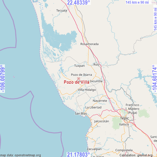
Pozo de Villa GPS coordinates[2]
21° 49' 55.92" North, 105° 18' 17.496" West
| Map corner | latitude | longitude |
|---|---|---|
| Upper-left | 22.48339°, | -106.00799° |
| Center: | 21.8322°, | -105.30486° |
| Lower-right: | 21.17803°, | -104.60174° |
| Map W x H: | 145.1×145.1 km | = 90.2×90.2mi |
| max Lat: | 32.7° ⇑16.9% North |
| Pozo de Villa: | 21.8322° |
| min Lat: | ⇓83.1% South 14.53588° |
| min Long | Pozo de Villa | max Long |
| -117.105° | -105.30486° | -86.73105° |
| W 7.3%⇐ | ⇒92.7% E |
Elevation
Elevation of Pozo de Villa is 12 m = 39 ft, and this is 1241.7 m = 4074 ft below average elevation for this country.
| Max E: |
3497 m = 11473 ft | 95.7% |
| Avg. | 1253.7 m = 4113 ft | |
| Pozo de Villa | 12 m = 39 ft | |
Min E: |
-1 m = -3 ft | 4.3% |
See also: Mexico elevation on elevation.city.
Geographical zone
Pozo de Villa is located in North Torrid zone (between Equator and Tropic of Cancer). Distance of this Northern Tropic circle is 178.4 km =110.9 mi to North.| Distance of | km | miles | from Pozo de Villa |
|---|---|---|---|
| North Pole | 7579.5 | 4709.7 | to North |
| Arctic Circle | 4973.7 | 3090.5 | to North |
| Tropic Cancer | 178.4 | 110.9 | to North |
| Equator | 2427.5 | 1508.4 | to South |


Nearby cities:
15 places around Pozo de Villa: (largest is in red/bold)
• Amapa
7.5 km =4.7 mi,  136°
136°
• Cerritos
6.6 km =4.1 mi,  148°
148°
• Colonia Emiliano Zapata
8.8 km =5.5 mi,  92°
92°
• El Botadero
8.9 km =5.5 mi,  167°
167°
• El Limón
2 km =1.2 mi,  303°
303°
• El Puente
6.3 km =3.9 mi,  71°
71°
• Gavilán Grande
3.9 km =2.4 mi,  161°
161°
• La Presa
11.3 km =7 mi,  108°
108°
• Paredones (La Punta de la Laguna)
10.9 km =6.8 mi, 66°
• Pozo de Ibarra
4.7 km =2.9 mi,  34°
34°
• Pueblo Nuevo
6.7 km =4.2 mi,  184°
184°
• San Miguel Número Dos (El Quemado)
8.9 km =5.5 mi,  267°
267°
• Santiago Ixcuintla
10.2 km =6.3 mi,  102°
102°
• Sentispac
5.2 km =3.2 mi,  234°
234°
• Valle Morelos
2.5 km =1.6 mi, 66°
Sources, notices
• [Note1] Compared only with cities in Mexico existing in our database
• [Src1] Map data: © OpenStreetMap contributors (CC-BY-SA)
• [Src2] Other city data from geonames.org with taken over terms of usage.
• [Src3] Geographical zone / Annual Mean Temperature by Robert A. Rohde @ Wikipedia
