Charapán geodata
Charapán (Michoacán) is a populated place; located in Mexico in America/Mexico_City (GMT-6) time zone. With population of 3,968 people, there are 2295 cities with bigger population in this country. Compared to other cities in Mexico, 50.9% of cities are located further ↑North; 82.4% of cities are located further →East and 88.9% of cities have lower elevation than Charapán. Note1


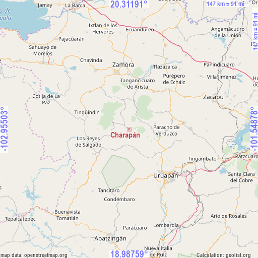
Charapán GPS coordinates[2]
19° 39' 4.032" North, 102° 15' 6.84" West
| Map corner | latitude | longitude |
|---|---|---|
| Upper-left | 20.31191°, | -102.95503° |
| Center: | 19.65112°, | -102.2519° |
| Lower-right: | 18.98759°, | -101.54878° |
| Map W x H: | 147.3×147.3 km | = 91.5×91.5mi |
| max Lat: | 32.7° ⇑50.9% North |
| Charapán: | 19.65112° |
| min Lat: | ⇓49.1% South 14.53588° |
| min Long | Charapán | max Long |
| -117.105° | -102.2519° | -86.73105° |
| W 17.6%⇐ | ⇒82.4% E |
Elevation
Elevation of Charapán is 2368 m = 7769 ft, and this is 1114.3 m = 3656 ft above average elevation for this country.
| Max E: |
3497 m = 11473 ft | 11.1% |
| Charapán | 2368 m 7769 ft | |
| Avg. | 1253.7 m = 4113 ft | |
Min E: |
-1 m = -3 ft | 88.9% |
See also: Mexico elevation on elevation.city.
Geographical zone
Charapán is located in North Torrid zone (between Equator and Tropic of Cancer). Distance of this Northern Tropic circle is 420.9 km =261.5 mi to North.| Distance of | km | miles | from Charapán |
|---|---|---|---|
| North Pole | 7822.1 | 4860.4 | to North |
| Arctic Circle | 5216.2 | 3241.2 | to North |
| Tropic Cancer | 420.9 | 261.5 | to North |
| Equator | 2185 | 1357.7 | to South |


Nearby cities:
15 places around Charapán: (largest is in red/bold)
• Angahuán
11.8 km =7.3 mi,  166°
166°
• Cherato
10.8 km =6.7 mi,  257°
257°
• Cocucho
8.2 km =5.1 mi,  53°
53°
• Corupo
5 km =3.1 mi,  159°
159°
• La Palma
10.3 km =6.4 mi,  239°
239°
• Nurío
12.8 km =8 mi,  87°
87°
• Pamatácuaro
10.8 km =6.7 mi,  294°
294°
• San Benito
9.6 km =6 mi,  310°
310°
• San Felipe de los Herreros
8.3 km =5.2 mi,  117°
117°
• San Isidro
10.9 km =6.8 mi,  334°
334°
• Santa Ana Zirosto
15 km =9.3 mi,  210°
210°
• Santa María Urapicho
15 km =9.3 mi,  77°
77°
• Urengüitiro (San Martín)
12.3 km =7.6 mi, 333°
• Zacán
10.2 km =6.3 mi,  201°
201°
• Zicuicho
8.6 km =5.3 mi,  278°
278°
Sources, notices
• [Note1] Compared only with cities in Mexico existing in our database
• [Src1] Map data: © OpenStreetMap contributors (CC-BY-SA)
• [Src2] Other city data from geonames.org with taken over terms of usage.
• [Src3] Geographical zone / Annual Mean Temperature by Robert A. Rohde @ Wikipedia
