Naco geodata
Naco (Sonora) is a seat of a second-order administrative division; located in Mexico in America/Hermosillo (GMT-7) time zone. With population of 6,064 people, there are 1541 cities with bigger population in this country. Compared to other cities in Mexico, 99.1% of cities are located further ↓South; 98.1% of cities are located further →East and 50.2% of cities have higher elevation than Naco. Note1


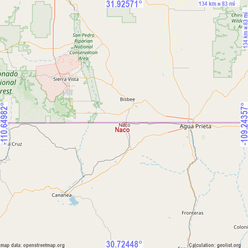
Naco GPS coordinates[2]
31° 19' 37.236" North, 109° 56' 48.084" West
| Map corner | latitude | longitude |
|---|---|---|
| Upper-left | 31.92571°, | -110.64982° |
| Center: | 31.32701°, | -109.94669° |
| Lower-right: | 30.72448°, | -109.24357° |
| Map W x H: | 133.6×133.6 km | = 83×83mi |
| max Lat: | 32.7° ⇑0.9% North |
| Naco: | 31.32701° |
| min Lat: | ⇓99.1% South 14.53588° |
| min Long | Naco | max Long |
| -117.105° | -109.94669° | -86.73105° |
| W 1.9%⇐ | ⇒98.1% E |
Elevation
Elevation of Naco is 1423 m = 4669 ft, and this is 169.3 m = 555 ft above average elevation for this country.
| Max E: |
3497 m = 11473 ft | 50.2% |
| Naco | 1423 m 4669 ft | |
| Avg. | 1253.7 m = 4113 ft | |
Min E: |
-1 m = -3 ft | 49.8% |
See also: Mexico elevation on elevation.city.
Geographical zone
Naco is located in North temperate zone (between Tropic of Cancer and the Arctic Circle). Distance of this Northern Tropic circle is 877.3 km =545.1 mi to South.| Distance of | km | miles | from Naco |
|---|---|---|---|
| North Pole | 6523.8 | 4053.7 | to North |
| Arctic Circle | 3917.9 | 2434.5 | to North |
| Tropic Cancer | 877.3 | 545.1 | to South |
| Equator | 3483.2 | 2164.4 | to South |


Nearby cities:
15 places around Naco: (largest is in red/bold)
• Agua Prieta
37.8 km =23.5 mi,  89°
89°
• Bacoachi
77.3 km =48 mi,  181°
181°
• Campo Carretero
106.2 km =66 mi,  234°
234°
• Cananea
50 km =31.1 mi,  220°
220°
• Centro de Readaptación Social Nuevo
98.3 km =61.1 mi,  260°
260°
• Cíbuta
95.2 km =59.2 mi,  251°
251°
• Esqueda
75.2 km =46.7 mi,  153°
153°
• Francisco Miguel Cárdenas Valdez (Mascareñas)
80.7 km =50.1 mi,  265°
265°
• Fronteras
60.3 km =37.5 mi,  142°
142°
• Imuris
104.4 km =64.9 mi,  235°
235°
• La Mesa
99.5 km =61.8 mi, 259°
• Miguel Hidalgo
69.2 km =43 mi, 253°
• Nacozari Viejo
106.9 km =66.4 mi,  164°
164°
• Nogales
94.6 km =58.8 mi, 268°
• Santa Cruz
62.6 km =38.9 mi, 260°
Sources, notices
• [Note1] Compared only with cities in Mexico existing in our database
• [Src1] Map data: © OpenStreetMap contributors (CC-BY-SA)
• [Src2] Other city data from geonames.org with taken over terms of usage.
• [Src3] Geographical zone / Annual Mean Temperature by Robert A. Rohde @ Wikipedia
