Moyahua de Estrada geodata
Moyahua de Estrada (Zacatecas) is a seat of a second-order administrative division; located in Mexico in America/Mexico_City (GMT-6) time zone. With population of 2,132 people, there are 4107 cities with bigger population in this country. Compared to other cities in Mexico, 79.7% of cities are located further ↓South; 86.4% of cities are located further →East and 55.6% of cities have higher elevation than Moyahua de Estrada. Note1


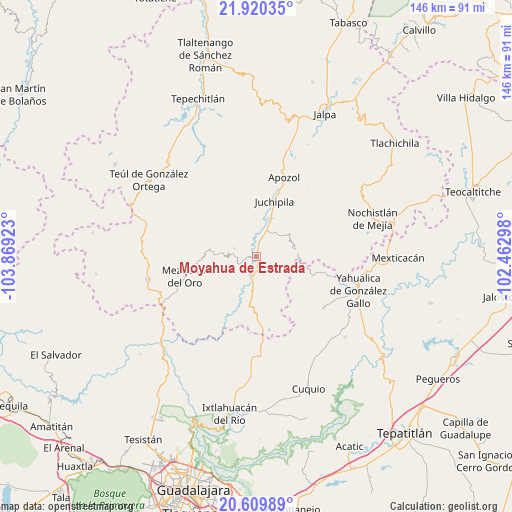
Moyahua de Estrada GPS coordinates[2]
21° 15' 59.688" North, 103° 9' 57.96" West
| Map corner | latitude | longitude |
|---|---|---|
| Upper-left | 21.92035°, | -103.86923° |
| Center: | 21.26658°, | -103.1661° |
| Lower-right: | 20.60989°, | -102.46298° |
| Map W x H: | 145.7×145.7 km | = 90.5×90.5mi |
| max Lat: | 32.7° ⇑20.3% North |
| Moyahua de Estrada: | 21.26658° |
| min Lat: | ⇓79.7% South 14.53588° |
| min Long | Moyahua de Estr | max Long |
| -117.105° | -103.1661° | -86.73105° |
| W 13.6%⇐ | ⇒86.4% E |
Elevation
Elevation of Moyahua de Estrada is 1175 m = 3855 ft, and this is 78.7 m = 258 ft below average elevation for this country.
| Max E: |
3497 m = 11473 ft | 55.6% |
| Avg. | 1253.7 m = 4113 ft | |
| Moyahua de Estrada | 1175 m = 3855 ft | |
Min E: |
-1 m = -3 ft | 44.4% |
See also: Mexico elevation on elevation.city.
Geographical zone
Moyahua de Estrada is located in North Torrid zone (between Equator and Tropic of Cancer). Distance of this Northern Tropic circle is 241.3 km =149.9 mi to North.| Distance of | km | miles | from Moyahua de Estrada |
|---|---|---|---|
| North Pole | 7642.4 | 4748.8 | to North |
| Arctic Circle | 5036.6 | 3129.6 | to North |
| Tropic Cancer | 241.3 | 149.9 | to North |
| Equator | 2364.6 | 1469.3 | to South |


Nearby cities:
15 places around Moyahua de Estrada: (largest is in red/bold)
• Apozol
23.9 km =14.9 mi,  19°
19°
• Bonifacio Falcón
16.6 km =10.3 mi,  13°
13°
• Cuxpala
6.8 km =4.2 mi,  292°
292°
• Daniel Camarena
29.6 km =18.4 mi,  72°
72°
• El Remolino
11.7 km =7.3 mi, 21°
• Huisquilco
24 km =14.9 mi,  127°
127°
• Juchipila
16.6 km =10.3 mi, 17°
• Juchitlán
27.7 km =17.2 mi,  154°
154°
• Las Cruces
27.6 km =17.1 mi,  168°
168°
• Los Llamas
27.4 km =17 mi, 16°
• Mezquital del Oro
21.1 km =13.1 mi,  254°
254°
• San Gabriel
31.7 km =19.7 mi, 150°
• San José (San José de los Meléndez)
17.7 km =11 mi, 13°
• Trinidad García de la Cadena
31.6 km =19.6 mi,  258°
258°
• Yahualica de González Gallo
30.6 km =19 mi,  108°
108°
Sources, notices
• [Note1] Compared only with cities in Mexico existing in our database
• [Src1] Map data: © OpenStreetMap contributors (CC-BY-SA)
• [Src2] Other city data from geonames.org with taken over terms of usage.
• [Src3] Geographical zone / Annual Mean Temperature by Robert A. Rohde @ Wikipedia
