Matachí geodata
Matachí (Chihuahua) is a seat of a second-order administrative division; located in Mexico in America/Chihuahua (GMT-6) time zone. With population of 1,710 people, there are 5082 cities with bigger population in this country. Compared to other cities in Mexico, 98% of cities are located further ↓South; 95.4% of cities are located further →East and 68.6% of cities have lower elevation than Matachí. Note1


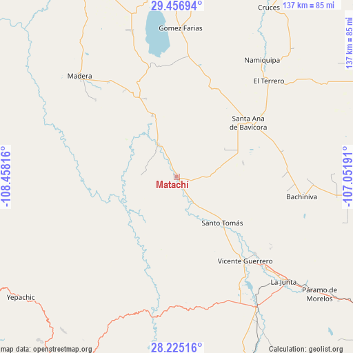
Matachí GPS coordinates[2]
28° 50' 34.332" North, 107° 45' 18.108" West
| Map corner | latitude | longitude |
|---|---|---|
| Upper-left | 29.45694°, | -108.45816° |
| Center: | 28.84287°, | -107.75503° |
| Lower-right: | 28.22516°, | -107.05191° |
| Map W x H: | 137×137 km | = 85.1×85.1mi |
| max Lat: | 32.7° ⇑2% North |
| Matachí: | 28.84287° |
| min Lat: | ⇓98% South 14.53588° |
| min Long | Matachí | max Long |
| -117.105° | -107.75503° | -86.73105° |
| W 4.6%⇐ | ⇒95.4% E |
Elevation
Elevation of Matachí is 1899 m = 6230 ft, and this is 645.3 m = 2117 ft above average elevation for this country.
| Max E: |
3497 m = 11473 ft | 31.4% |
| Matachí | 1899 m 6230 ft | |
| Avg. | 1253.7 m = 4113 ft | |
Min E: |
-1 m = -3 ft | 68.6% |
See also: Mexico elevation on elevation.city.
Geographical zone
Matachí is located in North temperate zone (between Tropic of Cancer and the Arctic Circle). Distance of this Northern Tropic circle is 601.1 km =373.5 mi to South.| Distance of | km | miles | from Matachí |
|---|---|---|---|
| North Pole | 6800 | 4225.3 | to North |
| Arctic Circle | 4194.1 | 2606.1 | to North |
| Tropic Cancer | 601.1 | 373.5 | to South |
| Equator | 3207 | 1992.7 | to South |


Nearby cities:
15 places around Matachí: (largest is in red/bold)
• Abraham González
35 km =21.7 mi,  64°
64°
• Bachíniva
49.4 km =30.7 mi,  99°
99°
• Basúchil
49.4 km =30.7 mi,  135°
135°
• Borjas
47.5 km =29.5 mi, 136°
• El Molino
51.5 km =32 mi,  41°
41°
• El Terrero
51.9 km =32.2 mi, 43°
• Guerrero
42.1 km =26.2 mi, 141°
• Independencia
34.6 km =21.5 mi, 36°
• La Pinta
44 km =27.3 mi,  10°
10°
• Madera
54.5 km =33.9 mi,  315°
315°
• Oscar Soto Maynez
34.5 km =21.4 mi,  52°
52°
• Peña Blanca
49.9 km =31 mi,  4°
4°
• San José Bavícora
45.3 km =28.1 mi, 0°
• Santo Tomás
25.2 km =15.7 mi, 135°
• Temósachic
14.4 km =8.9 mi,  329°
329°
Sources, notices
• [Note1] Compared only with cities in Mexico existing in our database
• [Src1] Map data: © OpenStreetMap contributors (CC-BY-SA)
• [Src2] Other city data from geonames.org with taken over terms of usage.
• [Src3] Geographical zone / Annual Mean Temperature by Robert A. Rohde @ Wikipedia
