La Estrella geodata
La Estrella (Jalisco) is a populated place; located in Mexico in America/Mexico_City (GMT-6) time zone. With population of 600 people, there are 14337 cities with bigger population in this country. Compared to other cities in Mexico, 60.7% of cities are located further ↑North; 88.1% of cities are located further →East and 65.2% of cities have higher elevation than La Estrella. Note1


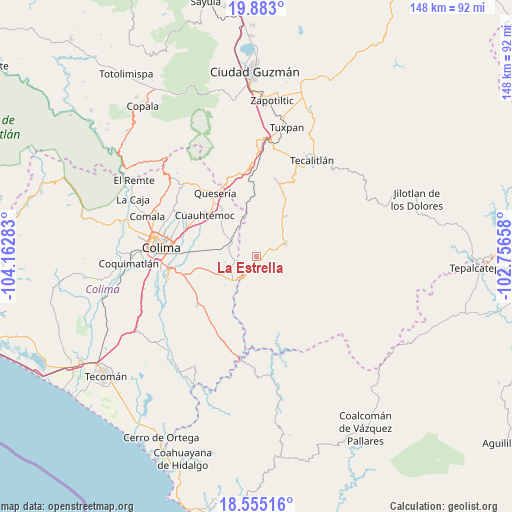
La Estrella GPS coordinates[2]
19° 13' 13.512" North, 103° 27' 34.92" West
| Map corner | latitude | longitude |
|---|---|---|
| Upper-left | 19.883°, | -104.16283° |
| Center: | 19.22042°, | -103.4597° |
| Lower-right: | 18.55516°, | -102.75658° |
| Map W x H: | 147.6×147.6 km | = 91.7×91.7mi |
| max Lat: | 32.7° ⇑60.7% North |
| La Estrella: | 19.22042° |
| min Lat: | ⇓39.3% South 14.53588° |
| min Long | La Estrella | max Long |
| -117.105° | -103.4597° | -86.73105° |
| W 11.9%⇐ | ⇒88.1% E |
Elevation
Elevation of La Estrella is 677 m = 2221 ft, and this is 576.7 m = 1892 ft below average elevation for this country.
| Max E: |
3497 m = 11473 ft | 65.2% |
| Avg. | 1253.7 m = 4113 ft | |
| La Estrella | 677 m = 2221 ft | |
Min E: |
-1 m = -3 ft | 34.8% |
See also: Mexico elevation on elevation.city.
Geographical zone
La Estrella is located in North Torrid zone (between Equator and Tropic of Cancer). Distance of this Northern Tropic circle is 468.8 km =291.3 mi to North.| Distance of | km | miles | from La Estrella |
|---|---|---|---|
| North Pole | 7870 | 4890.2 | to North |
| Arctic Circle | 5264.1 | 3271 | to North |
| Tropic Cancer | 468.8 | 291.3 | to North |
| Equator | 2137.1 | 1327.9 | to South |


Nearby cities:
15 places around La Estrella: (largest is in red/bold)
• Alcaraces
20.2 km =12.6 mi,  322°
322°
• Alzada
8.5 km =5.3 mi,  299°
299°
• Buenavista
16.2 km =10.1 mi,  281°
281°
• Chiapa
24.2 km =15 mi, 302°
• Cofradía
25.5 km =15.8 mi,  338°
338°
• Cuauhtémoc
19.2 km =11.9 mi,  308°
308°
• El Pozo Santo (Crucero del Tule)
14.1 km =8.8 mi,  33°
33°
• El Trapiche
22.1 km =13.7 mi,  286°
286°
• La Higuera
23.2 km =14.4 mi,  13°
13°
• Los Tepames
22.1 km =13.7 mi,  230°
230°
• Ocotillo
23.6 km =14.7 mi, 302°
• Palmillas
17.5 km =10.9 mi,  326°
326°
• Pihuamo
8.7 km =5.4 mi,  67°
67°
• Quesería
22 km =13.7 mi, 327°
• Tonila
24.4 km =15.2 mi,  345°
345°
Sources, notices
• [Note1] Compared only with cities in Mexico existing in our database
• [Src1] Map data: © OpenStreetMap contributors (CC-BY-SA)
• [Src2] Other city data from geonames.org with taken over terms of usage.
• [Src3] Geographical zone / Annual Mean Temperature by Robert A. Rohde @ Wikipedia
