El Tule geodata
El Tule (Chihuahua) is a seat of a second-order administrative division; located in Mexico in America/Chihuahua (GMT-6) time zone. With population of 811 people, there are 10778 cities with bigger population in this country. Compared to other cities in Mexico, 96.4% of cities are located further ↓South; 94% of cities are located further →East and 54.3% of cities have lower elevation than El Tule. Note1


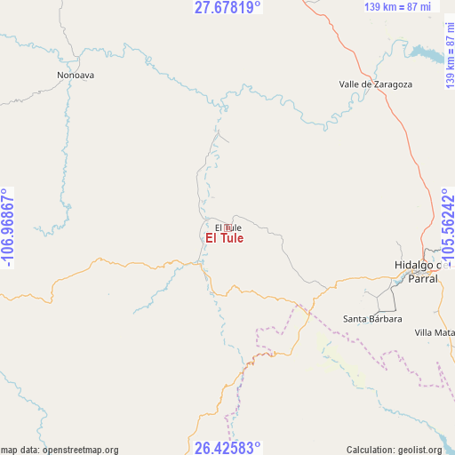
El Tule GPS coordinates[2]
27° 3' 13.536" North, 106° 15' 55.944" West
| Map corner | latitude | longitude |
|---|---|---|
| Upper-left | 27.67819°, | -106.96867° |
| Center: | 27.05376°, | -106.26554° |
| Lower-right: | 26.42583°, | -105.56242° |
| Map W x H: | 139.2×139.3 km | = 86.5×86.6mi |
| max Lat: | 32.7° ⇑3.6% North |
| El Tule: | 27.05376° |
| min Lat: | ⇓96.4% South 14.53588° |
| min Long | El Tule | max Long |
| -117.105° | -106.26554° | -86.73105° |
| W 6%⇐ | ⇒94% E |
Elevation
Elevation of El Tule is 1569 m = 5148 ft, and this is 315.3 m = 1034 ft above average elevation for this country.
| Max E: |
3497 m = 11473 ft | 45.7% |
| El Tule | 1569 m 5148 ft | |
| Avg. | 1253.7 m = 4113 ft | |
Min E: |
-1 m = -3 ft | 54.3% |
See also: Mexico elevation on elevation.city.
Geographical zone
El Tule is located in North temperate zone (between Tropic of Cancer and the Arctic Circle). Distance of this Northern Tropic circle is 402.2 km =249.9 mi to South.| Distance of | km | miles | from El Tule |
|---|---|---|---|
| North Pole | 6999 | 4349 | to North |
| Arctic Circle | 4393.1 | 2729.7 | to North |
| Tropic Cancer | 402.2 | 249.9 | to South |
| Equator | 3008.1 | 1869.1 | to South |


Nearby cities:
15 places around El Tule: (largest is in red/bold)
• Balleza
14.1 km =8.8 mi,  216°
216°
• Ejido El Vergel
65.8 km =40.9 mi,  190°
190°
• El Oro
46.5 km =28.9 mi,  117°
117°
• Guachochi
84.3 km =52.4 mi,  252°
252°
• Huejotitán
8.7 km =5.4 mi,  88°
88°
• Mariano Balleza
13.7 km =8.5 mi, 215°
• Matamoros
74.8 km =46.5 mi, 115°
• Nonoava
65.8 km =40.9 mi,  315°
315°
• Norogachi
89 km =55.3 mi,  285°
285°
• Parral
60.9 km =37.8 mi,  103°
103°
• Santa Bárbara
52.2 km =32.4 mi, 122°
• Talamantes
83.6 km =51.9 mi, 100°
• Valle de Allende
87.5 km =54.4 mi, 98°
• Valle de Zaragoza
63.2 km =39.3 mi,  45°
45°
• Valle del Rosario
29.6 km =18.4 mi,  354°
354°
Sources, notices
• [Note1] Compared only with cities in Mexico existing in our database
• [Src1] Map data: © OpenStreetMap contributors (CC-BY-SA)
• [Src2] Other city data from geonames.org with taken over terms of usage.
• [Src3] Geographical zone / Annual Mean Temperature by Robert A. Rohde @ Wikipedia
