Tototlán geodata
Tototlán (Jalisco) is a seat of a second-order administrative division; located in Mexico in America/Mexico_City (GMT-6) time zone. With population of 12,516 people, there are 778 cities with bigger population in this country. Compared to other cities in Mexico, 68.7% of cities are located further ↓South; 85.1% of cities are located further →East and 53.3% of cities have lower elevation than Tototlán. Note1


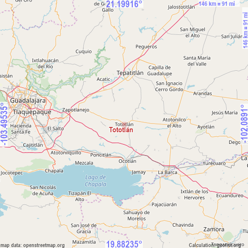
Tototlán GPS coordinates[2]
20° 32' 31.812" North, 102° 47' 31.992" West
| Map corner | latitude | longitude |
|---|---|---|
| Upper-left | 21.19916°, | -103.49535° |
| Center: | 20.54217°, | -102.79222° |
| Lower-right: | 19.88235°, | -102.0891° |
| Map W x H: | 146.4×146.4 km | = 91×91mi |
| max Lat: | 32.7° ⇑31.3% North |
| Tototlán: | 20.54217° |
| min Lat: | ⇓68.7% South 14.53588° |
| min Long | Tototlán | max Long |
| -117.105° | -102.79222° | -86.73105° |
| W 14.9%⇐ | ⇒85.1% E |
Elevation
Elevation of Tototlán is 1547 m = 5075 ft, and this is 293.3 m = 962 ft above average elevation for this country.
| Max E: |
3497 m = 11473 ft | 46.7% |
| Tototlán | 1547 m 5075 ft | |
| Avg. | 1253.7 m = 4113 ft | |
Min E: |
-1 m = -3 ft | 53.3% |
See also: Mexico elevation on elevation.city.
Geographical zone
Tototlán is located in North Torrid zone (between Equator and Tropic of Cancer). Distance of this Northern Tropic circle is 321.8 km =200 mi to North.| Distance of | km | miles | from Tototlán |
|---|---|---|---|
| North Pole | 7723 | 4798.8 | to North |
| Arctic Circle | 5117.1 | 3179.6 | to North |
| Tropic Cancer | 321.8 | 200 | to North |
| Equator | 2284.1 | 1419.3 | to South |


Nearby cities:
15 places around Tototlán: (largest is in red/bold)
• Capilla de Milpillas
14.5 km =9 mi,  338°
338°
• Carrozas
8.8 km =5.5 mi,  135°
135°
• Coina Grande
5.5 km =3.4 mi,  111°
111°
• El Sauz
7.1 km =4.4 mi,  188°
188°
• Joconoxtle (La Tuna)
15.7 km =9.8 mi,  129°
129°
• La Noria
11.2 km =7 mi,  210°
210°
• Los Cerritos
7.4 km =4.6 mi,  166°
166°
• Nuevo Refugio de Afuera (Nuevo Refugio)
8.9 km =5.5 mi,  85°
85°
• Otatlán
11.3 km =7 mi, 186°
• Ramblas Chico
8.9 km =5.5 mi,  347°
347°
• San Agustín
13 km =8.1 mi,  38°
38°
• San Isidro
8.6 km =5.3 mi,  66°
66°
• San Martín de Zula
16.2 km =10.1 mi,  155°
155°
• Tecomatlán
14.7 km =9.1 mi,  303°
303°
• Zapotlán del Rey
16.3 km =10.1 mi,  238°
238°
Sources, notices
• [Note1] Compared only with cities in Mexico existing in our database
• [Src1] Map data: © OpenStreetMap contributors (CC-BY-SA)
• [Src2] Other city data from geonames.org with taken over terms of usage.
• [Src3] Geographical zone / Annual Mean Temperature by Robert A. Rohde @ Wikipedia
