Cocucho geodata
Cocucho (Michoacán) is a populated place; located in Mexico in America/Mexico_City (GMT-6) time zone. With population of 2,838 people, there are 3127 cities with bigger population in this country. Compared to other cities in Mexico, 50.3% of cities are located further ↓South; 82% of cities are located further →East and 90.5% of cities have lower elevation than Cocucho. Note1


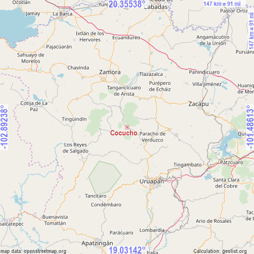
Cocucho GPS coordinates[2]
19° 41' 41.172" North, 102° 11' 21.3" West
| Map corner | latitude | longitude |
|---|---|---|
| Upper-left | 20.35538°, | -102.89238° |
| Center: | 19.69477°, | -102.18925° |
| Lower-right: | 19.03142°, | -101.48613° |
| Map W x H: | 147.2×147.2 km | = 91.5×91.5mi |
| max Lat: | 32.7° ⇑49.7% North |
| Cocucho: | 19.69477° |
| min Lat: | ⇓50.3% South 14.53588° |
| min Long | Cocucho | max Long |
| -117.105° | -102.18925° | -86.73105° |
| W 18%⇐ | ⇒82% E |
Elevation
Elevation of Cocucho is 2426 m = 7959 ft, and this is 1172.3 m = 3846 ft above average elevation for this country.
| Max E: |
3497 m = 11473 ft | 9.5% |
| Cocucho | 2426 m 7959 ft | |
| Avg. | 1253.7 m = 4113 ft | |
Min E: |
-1 m = -3 ft | 90.5% |
See also: Mexico elevation on elevation.city.
Geographical zone
Cocucho is located in North Torrid zone (between Equator and Tropic of Cancer). Distance of this Northern Tropic circle is 416.1 km =258.6 mi to North.| Distance of | km | miles | from Cocucho |
|---|---|---|---|
| North Pole | 7817.2 | 4857.4 | to North |
| Arctic Circle | 5211.3 | 3238.2 | to North |
| Tropic Cancer | 416.1 | 258.6 | to North |
| Equator | 2189.9 | 1360.7 | to South |


Nearby cities:
15 places around Cocucho: (largest is in red/bold)
• Ahuirán
12.5 km =7.8 mi,  104°
104°
• Charapán
8.2 km =5.1 mi,  233°
233°
• Corupo
10.7 km =6.6 mi,  206°
206°
• Huécato
7.9 km =4.9 mi,  37°
37°
• Nurío
7.6 km =4.7 mi,  124°
124°
• Ocumicho
11.8 km =7.3 mi,  343°
343°
• Pomacuarán
12.1 km =7.5 mi,  131°
131°
• San Benito
13.9 km =8.6 mi,  275°
275°
• San Felipe de los Herreros
8.7 km =5.4 mi,  174°
174°
• San Isidro
12.3 km =7.6 mi,  293°
293°
• San José de Gracia (San José Ocumicho)
14.7 km =9.1 mi, 344°
• Santa María Urapicho
8.2 km =5.1 mi, 100°
• Tanaco
12.3 km =7.6 mi,  66°
66°
• Urengüitiro (San Martín)
13.5 km =8.4 mi,  297°
297°
• Zicuicho
15.5 km =9.6 mi,  256°
256°
Sources, notices
• [Note1] Compared only with cities in Mexico existing in our database
• [Src1] Map data: © OpenStreetMap contributors (CC-BY-SA)
• [Src2] Other city data from geonames.org with taken over terms of usage.
• [Src3] Geographical zone / Annual Mean Temperature by Robert A. Rohde @ Wikipedia
