Bustamante geodata
Bustamante (Nuevo León) is a seat of a second-order administrative division; located in Mexico in America/Monterrey (GMT-6) time zone. With population of 3,640 people, there are 2517 cities with bigger population in this country. Compared to other cities in Mexico, 95.8% of cities are located further ↓South; 69.6% of cities are located further →East and 69.1% of cities have higher elevation than Bustamante. Note1


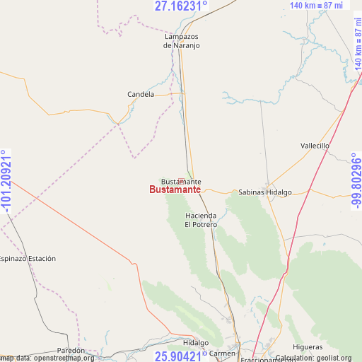
Bustamante GPS coordinates[2]
26° 32' 5.928" North, 100° 30' 21.888" West
| Map corner | latitude | longitude |
|---|---|---|
| Upper-left | 27.16231°, | -101.20921° |
| Center: | 26.53498°, | -100.50608° |
| Lower-right: | 25.90421°, | -99.80296° |
| Map W x H: | 139.9×139.9 km | = 86.9×86.9mi |
| max Lat: | 32.7° ⇑4.2% North |
| Bustamante: | 26.53498° |
| min Lat: | ⇓95.8% South 14.53588° |
| min Long | Bustamante | max Long |
| -117.105° | -100.50608° | -86.73105° |
| W 30.4%⇐ | ⇒69.6% E |
Elevation
Elevation of Bustamante is 461 m = 1512 ft, and this is 792.7 m = 2601 ft below average elevation for this country.
| Max E: |
3497 m = 11473 ft | 69.1% |
| Avg. | 1253.7 m = 4113 ft | |
| Bustamante | 461 m = 1512 ft | |
Min E: |
-1 m = -3 ft | 30.9% |
See also: Mexico elevation on elevation.city.
Geographical zone
Bustamante is located in North temperate zone (between Tropic of Cancer and the Arctic Circle). Distance of this Northern Tropic circle is 344.5 km =214.1 mi to South.| Distance of | km | miles | from Bustamante |
|---|---|---|---|
| North Pole | 7056.6 | 4384.8 | to North |
| Arctic Circle | 4450.8 | 2765.6 | to North |
| Tropic Cancer | 344.5 | 214.1 | to South |
| Equator | 2950.4 | 1833.3 | to South |


Nearby cities:
15 places around Bustamante: (largest is in red/bold)
• Abasolo
66.4 km =41.3 mi,  170°
170°
• Alberto Villarreal
66.4 km =41.3 mi, 171°
• Candela
37.3 km =23.2 mi,  334°
334°
• Ciudad Sabinas Hidalgo
32.4 km =20.1 mi,  96°
96°
• Ciudad de Villaldama
9 km =5.6 mi,  116°
116°
• El Potrero
16.6 km =10.3 mi,  153°
153°
• Hidalgo
62.8 km =39 mi, 174°
• Lampazos de Naranjo
54.5 km =33.9 mi,  0°
0°
• Las Torres
67.5 km =41.9 mi,  163°
163°
• Los Morales
57.3 km =35.6 mi, 161°
• Los Villarreales
56.8 km =35.3 mi, 161°
• Mamulique
53.8 km =33.4 mi, 149°
• Mina
59.4 km =36.9 mi,  182°
182°
• Salinas Victoria
67.1 km =41.7 mi, 161°
• Vallecillo
53.4 km =33.2 mi,  74°
74°
Sources, notices
• [Note1] Compared only with cities in Mexico existing in our database
• [Src1] Map data: © OpenStreetMap contributors (CC-BY-SA)
• [Src2] Other city data from geonames.org with taken over terms of usage.
• [Src3] Geographical zone / Annual Mean Temperature by Robert A. Rohde @ Wikipedia
