Cedros geodata
Cedros (Zacatecas) is a populated place; located in Mexico in America/Mexico_City (GMT-6) time zone. With population of 1,013 people, there are 8605 cities with bigger population in this country. Compared to other cities in Mexico, 91.2% of cities are located further ↓South; 79.6% of cities are located further →East and 62.5% of cities have lower elevation than Cedros. Note1


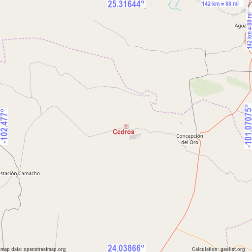
Cedros GPS coordinates[2]
24° 40' 45.084" North, 101° 46' 25.932" West
| Map corner | latitude | longitude |
|---|---|---|
| Upper-left | 25.31644°, | -102.477° |
| Center: | 24.67919°, | -101.77387° |
| Lower-right: | 24.03866°, | -101.07075° |
| Map W x H: | 142.1×142.1 km | = 88.3×88.3mi |
| max Lat: | 32.7° ⇑8.8% North |
| Cedros: | 24.67919° |
| min Lat: | ⇓91.2% South 14.53588° |
| min Long | Cedros | max Long |
| -117.105° | -101.77387° | -86.73105° |
| W 20.4%⇐ | ⇒79.6% E |
Elevation
Elevation of Cedros is 1768 m = 5801 ft, and this is 514.3 m = 1687 ft above average elevation for this country.
| Max E: |
3497 m = 11473 ft | 37.5% |
| Cedros | 1768 m 5801 ft | |
| Avg. | 1253.7 m = 4113 ft | |
Min E: |
-1 m = -3 ft | 62.5% |
See also: Mexico elevation on elevation.city.
Geographical zone
Cedros is located in North temperate zone (between Tropic of Cancer and the Arctic Circle). Distance of this Northern Tropic circle is 138.1 km =85.8 mi to South.| Distance of | km | miles | from Cedros |
|---|---|---|---|
| North Pole | 7263 | 4513 | to North |
| Arctic Circle | 4657.1 | 2893.8 | to North |
| Tropic Cancer | 138.1 | 85.8 | to South |
| Equator | 2744.1 | 1705.1 | to South |


Nearby cities:
15 places around Cedros: (largest is in red/bold)
• Agua Nueva
89.4 km =55.6 mi,  50°
50°
• Apizolaya
53 km =32.9 mi,  286°
286°
• Caopas
42 km =26.1 mi, 285°
• Colonia Fovissste
41.1 km =25.5 mi,  100°
100°
• Concepción del Oro
36.7 km =22.8 mi, 101°
• Derramadero
84 km =52.2 mi,  36°
36°
• Estación Camacho
66.1 km =41.1 mi,  246°
246°
• General Cepeda
83.3 km =51.8 mi,  21°
21°
• La Curva
39.7 km =24.7 mi, 99°
• Mazapil
22.6 km =14 mi, 101°
• Melchor Ocampo
21.5 km =13.4 mi, 38°
• San Juan de la Vaquería
84.8 km =52.7 mi, 41°
• San Tiburcio
66.1 km =41.1 mi,  153°
153°
• Tanque Nuevo
88 km =54.7 mi,  111°
111°
• Terminal de Providencia
31.2 km =19.4 mi,  87°
87°
Sources, notices
• [Note1] Compared only with cities in Mexico existing in our database
• [Src1] Map data: © OpenStreetMap contributors (CC-BY-SA)
• [Src2] Other city data from geonames.org with taken over terms of usage.
• [Src3] Geographical zone / Annual Mean Temperature by Robert A. Rohde @ Wikipedia
