Charapendo geodata
Charapendo (Michoacán) is a populated place; located in Mexico in America/Mexico_City (GMT-6) time zone. With population of 1,118 people, there are 7770 cities with bigger population in this country. Compared to other cities in Mexico, 59.6% of cities are located further ↑North; 81.3% of cities are located further →East and 59.9% of cities have higher elevation than Charapendo. Note1


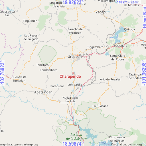
Charapendo GPS coordinates[2]
19° 15' 49.788" North, 102° 3' 57.96" West
| Map corner | latitude | longitude |
|---|---|---|
| Upper-left | 19.92623°, | -102.76923° |
| Center: | 19.26383°, | -102.0661° |
| Lower-right: | 18.59874°, | -101.36298° |
| Map W x H: | 147.6×147.6 km | = 91.7×91.7mi |
| max Lat: | 32.7° ⇑59.6% North |
| Charapendo: | 19.26383° |
| min Lat: | ⇓40.4% South 14.53588° |
| min Long | Charapendo | max Long |
| -117.105° | -102.0661° | -86.73105° |
| W 18.7%⇐ | ⇒81.3% E |
Elevation
Elevation of Charapendo is 1011 m = 3317 ft, and this is 242.7 m = 796 ft below average elevation for this country.
| Max E: |
3497 m = 11473 ft | 59.9% |
| Avg. | 1253.7 m = 4113 ft | |
| Charapendo | 1011 m = 3317 ft | |
Min E: |
-1 m = -3 ft | 40.1% |
See also: Mexico elevation on elevation.city.
Geographical zone
Charapendo is located in North Torrid zone (between Equator and Tropic of Cancer). Distance of this Northern Tropic circle is 464 km =288.3 mi to North.| Distance of | km | miles | from Charapendo |
|---|---|---|---|
| North Pole | 7865.1 | 4887.1 | to North |
| Arctic Circle | 5259.2 | 3267.9 | to North |
| Tropic Cancer | 464 | 288.3 | to North |
| Equator | 2141.9 | 1330.9 | to South |


Nearby cities:
15 places around Charapendo: (largest is in red/bold)
• Arandín
16.4 km =10.2 mi,  339°
339°
• Cutzato (Cuisato)
13.5 km =8.4 mi,  327°
327°
• El Arroyo Colorado
9.6 km =6 mi,  6°
6°
• El Caulote
16.9 km =10.5 mi,  204°
204°
• El Sabino
10.4 km =6.5 mi,  72°
72°
• Emiliano Zapata
16 km =9.9 mi,  59°
59°
• Jucutacato
12.7 km =7.9 mi,  353°
353°
• La Estancia
13.2 km =8.2 mi,  243°
243°
• Lombardía
11.9 km =7.4 mi,  172°
172°
• Los Bancos
17.3 km =10.7 mi, 238°
• Los Cajones
17.1 km =10.6 mi,  110°
110°
• Santa Casilda
17.1 km =10.6 mi,  136°
136°
• Santa Rosa (Santa Bárbara)
13.7 km =8.5 mi, 13°
• Tahuejo
12.8 km =8 mi, 61°
• Uruapan
16.4 km =10.2 mi,  3°
3°
Sources, notices
• [Note1] Compared only with cities in Mexico existing in our database
• [Src1] Map data: © OpenStreetMap contributors (CC-BY-SA)
• [Src2] Other city data from geonames.org with taken over terms of usage.
• [Src3] Geographical zone / Annual Mean Temperature by Robert A. Rohde @ Wikipedia
