Nuevo Tenancingo geodata
Nuevo Tenancingo (Puebla) is a populated place; located in Mexico in America/Mexico_City (GMT-6) time zone. With population of 531 people, there are 15939 cities with bigger population in this country. Compared to other cities in Mexico, 66.2% of cities are located further ↓South; 64.5% of cities are located further ←West and 65.1% of cities have higher elevation than Nuevo Tenancingo. Note1


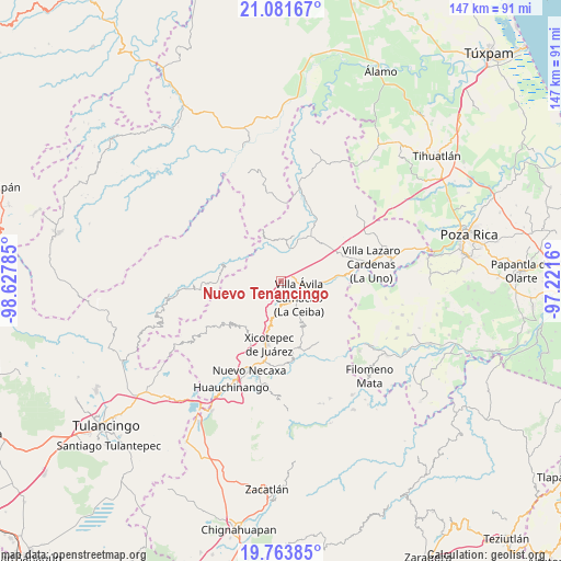
Nuevo Tenancingo GPS coordinates[2]
20° 25' 27.012" North, 97° 55' 28.992" West
| Map corner | latitude | longitude |
|---|---|---|
| Upper-left | 21.08167°, | -98.62785° |
| Center: | 20.42417°, | -97.92472° |
| Lower-right: | 19.76385°, | -97.2216° |
| Map W x H: | 146.5×146.5 km | = 91×91mi |
| max Lat: | 32.7° ⇑33.8% North |
| Nuevo Tenancingo: | 20.42417° |
| min Lat: | ⇓66.2% South 14.53588° |
| min Long | Nuevo Tenancing | max Long |
| -117.105° | -97.92472° | -86.73105° |
| W 64.5%⇐ | ⇒35.5% E |
Elevation
Elevation of Nuevo Tenancingo is 679 m = 2228 ft, and this is 574.7 m = 1885 ft below average elevation for this country.
| Max E: |
3497 m = 11473 ft | 65.1% |
| Avg. | 1253.7 m = 4113 ft | |
| Nuevo Tenancingo | 679 m = 2228 ft | |
Min E: |
-1 m = -3 ft | 34.9% |
See also: Mexico elevation on elevation.city.
Geographical zone
Nuevo Tenancingo is located in North Torrid zone (between Equator and Tropic of Cancer). Distance of this Northern Tropic circle is 335 km =208.2 mi to North.| Distance of | km | miles | from Nuevo Tenancingo |
|---|---|---|---|
| North Pole | 7736.1 | 4807 | to North |
| Arctic Circle | 5130.2 | 3187.8 | to North |
| Tropic Cancer | 335 | 208.2 | to North |
| Equator | 2271 | 1411.1 | to South |


Nearby cities:
15 places around Nuevo Tenancingo: (largest is in red/bold)
• Agua Linda
6.4 km =4 mi,  68°
68°
• Apapantilla
8.5 km =5.3 mi,  105°
105°
• Ejido de Jalpan
4.2 km =2.6 mi,  20°
20°
• El Rincón
8.6 km =5.3 mi,  278°
278°
• Gilberto Camacho
6.9 km =4.3 mi,  143°
143°
• Jalapilla
6.3 km =3.9 mi,  171°
171°
• Nuevo Carrizal
9 km =5.6 mi, 20°
• Papaloctipan
3.2 km =2 mi,  270°
270°
• Plan de Ayala
1 km =0.6 mi,  36°
36°
• San Lorenzo
8.3 km =5.2 mi,  188°
188°
• San Pedro Petlacotla
1.7 km =1.1 mi, 141°
• Tlaxco
10.9 km =6.8 mi, 269°
• Villa Avila Camacho
6.3 km =3.9 mi,  132°
132°
• Vista Hermosa
7.1 km =4.4 mi, 19°
• Zacatal
8.5 km =5.3 mi,  224°
224°
Sources, notices
• [Note1] Compared only with cities in Mexico existing in our database
• [Src1] Map data: © OpenStreetMap contributors (CC-BY-SA)
• [Src2] Other city data from geonames.org with taken over terms of usage.
• [Src3] Geographical zone / Annual Mean Temperature by Robert A. Rohde @ Wikipedia
