Sosa geodata
Sosa (Puebla) is a populated place; located in Mexico in America/Mexico_City (GMT-6) time zone. With population of 3,530 people, there are 2584 cities with bigger population in this country. Compared to other cities in Mexico, 52.8% of cities are located further ↓South; 70.6% of cities are located further ←West and 80.9% of cities have lower elevation than Sosa. Note1


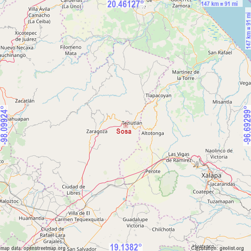
Sosa GPS coordinates[2]
19° 48' 3.996" North, 97° 23' 45.996" West
| Map corner | latitude | longitude |
|---|---|---|
| Upper-left | 20.46127°, | -98.09924° |
| Center: | 19.80111°, | -97.39611° |
| Lower-right: | 19.1382°, | -96.69299° |
| Map W x H: | 147.1×147.1 km | = 91.4×91.4mi |
| max Lat: | 32.7° ⇑47.2% North |
| Sosa: | 19.80111° |
| min Lat: | ⇓52.8% South 14.53588° |
| min Long | Sosa | max Long |
| -117.105° | -97.39611° | -86.73105° |
| W 70.6%⇐ | ⇒29.4% E |
Elevation
Elevation of Sosa is 2162 m = 7093 ft, and this is 908.3 m = 2980 ft above average elevation for this country.
| Max E: |
3497 m = 11473 ft | 19.1% |
| Sosa | 2162 m 7093 ft | |
| Avg. | 1253.7 m = 4113 ft | |
Min E: |
-1 m = -3 ft | 80.9% |
See also: Mexico elevation on elevation.city.
Geographical zone
Sosa is located in North Torrid zone (between Equator and Tropic of Cancer). Distance of this Northern Tropic circle is 404.2 km =251.2 mi to North.| Distance of | km | miles | from Sosa |
|---|---|---|---|
| North Pole | 7805.4 | 4850 | to North |
| Arctic Circle | 5199.5 | 3230.8 | to North |
| Tropic Cancer | 404.2 | 251.2 | to North |
| Equator | 2201.7 | 1368.1 | to South |


Nearby cities:
15 places around Sosa: (largest is in red/bold)
• Analco
2 km =1.2 mi,  348°
348°
• Apatauyan
5.1 km =3.2 mi,  267°
267°
• Cala Sur
4.4 km =2.7 mi,  323°
323°
• Chinautla
2.2 km =1.4 mi,  20°
20°
• Coahuixco
1.6 km =1 mi,  288°
288°
• Crutzitzin
0.5 km =0.3 mi,  156°
156°
• San Isidro
1.4 km =0.9 mi,  111°
111°
• Sección 23
2.3 km =1.4 mi,  129°
129°
• Talzintán
2.1 km =1.3 mi,  261°
261°
• Tepepan
3.8 km =2.4 mi, 22°
• Tequimila
2.9 km =1.8 mi,  31°
31°
• Teziutlan
4.2 km =2.6 mi,  64°
64°
• Tezohuatepec (Tezotepec)
1 km =0.6 mi,  341°
341°
• Xoloateno
4.3 km =2.7 mi,  39°
39°
• Yopi
3.3 km =2.1 mi, 30°
Sources, notices
• [Note1] Compared only with cities in Mexico existing in our database
• [Src1] Map data: © OpenStreetMap contributors (CC-BY-SA)
• [Src2] Other city data from geonames.org with taken over terms of usage.
• [Src3] Geographical zone / Annual Mean Temperature by Robert A. Rohde @ Wikipedia
