Teozintla geodata
Teozintla (Guerrero) is a populated place; located in Mexico in America/Mexico_City (GMT-6) time zone. With population of 502 people, there are 16762 cities with bigger population in this country. Compared to other cities in Mexico, 85.6% of cities are located further ↑North; 51.8% of cities are located further →East and 66.1% of cities have higher elevation than Teozintla. Note1


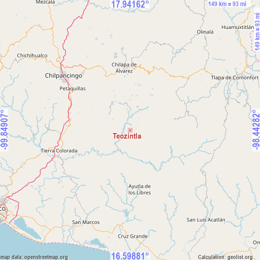
Teozintla GPS coordinates[2]
17° 16' 17.184" North, 99° 8' 45.384" West
| Map corner | latitude | longitude |
|---|---|---|
| Upper-left | 17.94162°, | -99.84907° |
| Center: | 17.27144°, | -99.14594° |
| Lower-right: | 16.59881°, | -98.44282° |
| Map W x H: | 149.3×149.3 km | = 92.8×92.8mi |
| max Lat: | 32.7° ⇑85.6% North |
| Teozintla: | 17.27144° |
| min Lat: | ⇓14.4% South 14.53588° |
| min Long | Teozintla | max Long |
| -117.105° | -99.14594° | -86.73105° |
| W 48.2%⇐ | ⇒51.8% E |
Elevation
Elevation of Teozintla is 631 m = 2070 ft, and this is 622.7 m = 2043 ft below average elevation for this country.
| Max E: |
3497 m = 11473 ft | 66.1% |
| Avg. | 1253.7 m = 4113 ft | |
| Teozintla | 631 m = 2070 ft | |
Min E: |
-1 m = -3 ft | 33.9% |
See also: Mexico elevation on elevation.city.
Geographical zone
Teozintla is located in North Torrid zone (between Equator and Tropic of Cancer). Distance of this Northern Tropic circle is 685.5 km =425.9 mi to North.| Distance of | km | miles | from Teozintla |
|---|---|---|---|
| North Pole | 8086.7 | 5024.8 | to North |
| Arctic Circle | 5480.8 | 3405.6 | to North |
| Tropic Cancer | 685.5 | 425.9 | to North |
| Equator | 1920.4 | 1193.3 | to South |


Nearby cities:
15 places around Teozintla: (largest is in red/bold)
• Colotlipa
15.8 km =9.8 mi,  351°
351°
• El Epazote
14.4 km =8.9 mi,  42°
42°
• El Tejoruco
4.3 km =2.7 mi,  144°
144°
• Jocutla
8 km =5 mi,  6°
6°
• Llano Grande
14.5 km =9 mi,  19°
19°
• Nanzintla
8.7 km =5.4 mi, 35°
• Plan de Gatica
15.9 km =9.9 mi,  170°
170°
• Pueblo Viejo
14.4 km =8.9 mi,  249°
249°
• San José
3.4 km =2.1 mi,  80°
80°
• San Marcos
17.2 km =10.7 mi,  60°
60°
• Santa Cruz
13.2 km =8.2 mi,  289°
289°
• Santa Fe
16.7 km =10.4 mi,  340°
340°
• Tierra Blanca
15.7 km =9.8 mi,  147°
147°
• Tlanicuilulco
13.8 km =8.6 mi, 18°
• Xochitepec
13.1 km =8.1 mi,  220°
220°
Sources, notices
• [Note1] Compared only with cities in Mexico existing in our database
• [Src1] Map data: © OpenStreetMap contributors (CC-BY-SA)
• [Src2] Other city data from geonames.org with taken over terms of usage.
• [Src3] Geographical zone / Annual Mean Temperature by Robert A. Rohde @ Wikipedia
