Cantón Villaflor geodata
Cantón Villaflor (Chiapas) is a populated place; located in Mexico in America/Mexico_City (GMT-6) time zone. With population of 1,046 people, there are 8327 cities with bigger population in this country. Compared to other cities in Mexico, 99.2% of cities are located further ↑North; 93% of cities are located further ←West and 74.3% of cities have higher elevation than Cantón Villaflor. Note1


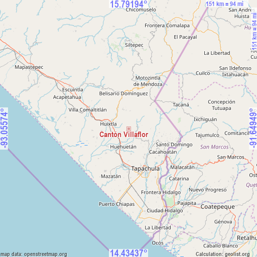
Cantón Villaflor GPS coordinates[2]
15° 6' 51.264" North, 92° 21' 9.396" West
| Map corner | latitude | longitude |
|---|---|---|
| Upper-left | 15.79194°, | -93.05574° |
| Center: | 15.11424°, | -92.35261° |
| Lower-right: | 14.43437°, | -91.64949° |
| Map W x H: | 150.9×151 km | = 93.8×93.8mi |
| max Lat: | 32.7° ⇑99.2% North |
| Cantón Villaflor: | 15.11424° |
| min Lat: | ⇓0.8% South 14.53588° |
| min Long | Cantón Villafl | max Long |
| -117.105° | -92.35261° | -86.73105° |
| W 93%⇐ | ⇒7% E |
Elevation
Elevation of Cantón Villaflor is 244 m = 801 ft, and this is 1009.7 m = 3313 ft below average elevation for this country.
| Max E: |
3497 m = 11473 ft | 74.3% |
| Avg. | 1253.7 m = 4113 ft | |
| Cantón Villaflor | 244 m = 801 ft | |
Min E: |
-1 m = -3 ft | 25.7% |
See also: Mexico elevation on elevation.city.
Geographical zone
Cantón Villaflor is located in North Torrid zone (between Equator and Tropic of Cancer). Distance of this Northern Tropic circle is 925.4 km =575 mi to North.| Distance of | km | miles | from Cantón Villaflor |
|---|---|---|---|
| North Pole | 8326.5 | 5173.8 | to North |
| Arctic Circle | 5720.6 | 3554.6 | to North |
| Tropic Cancer | 925.4 | 575 | to North |
| Equator | 1680.5 | 1044.2 | to South |


Nearby cities:
15 places around Cantón Villaflor: (largest is in red/bold)
• Cantón Sinaí
9.6 km =6 mi,  17°
17°
• Chamulapa
8.7 km =5.4 mi,  219°
219°
• Chamulapita
5.4 km =3.4 mi,  199°
199°
• El Chipilín
8 km =5 mi,  275°
275°
• El Edén
8.2 km =5.1 mi,  136°
136°
• Francisco Sarabia 1ra. Sección
7.4 km =4.6 mi,  312°
312°
• Guadalupe Victoria
7.9 km =4.9 mi, 313°
• Independencia
9.6 km =6 mi,  130°
130°
• Manacal
7.3 km =4.5 mi,  340°
340°
• Primer Cantón
9.4 km =5.8 mi,  274°
274°
• Segundo Cantón
9 km =5.6 mi,  260°
260°
• Tuzantán
8.3 km =5.2 mi,  296°
296°
• Villa Hidalgo
2.5 km =1.6 mi,  249°
249°
• Xochiltepec
8.9 km =5.5 mi, 279°
• Zaragoza
5.4 km =3.4 mi,  69°
69°
Sources, notices
• [Note1] Compared only with cities in Mexico existing in our database
• [Src1] Map data: © OpenStreetMap contributors (CC-BY-SA)
• [Src2] Other city data from geonames.org with taken over terms of usage.
• [Src3] Geographical zone / Annual Mean Temperature by Robert A. Rohde @ Wikipedia
