Chamulapita geodata
Chamulapita (Chiapas) is a populated place; located in Mexico in America/Mexico_City (GMT-6) time zone. With population of 1,337 people, there are 6503 cities with bigger population in this country. Compared to other cities in Mexico, 99.3% of cities are located further ↑North; 93% of cities are located further ←West and 79% of cities have higher elevation than Chamulapita. Note1


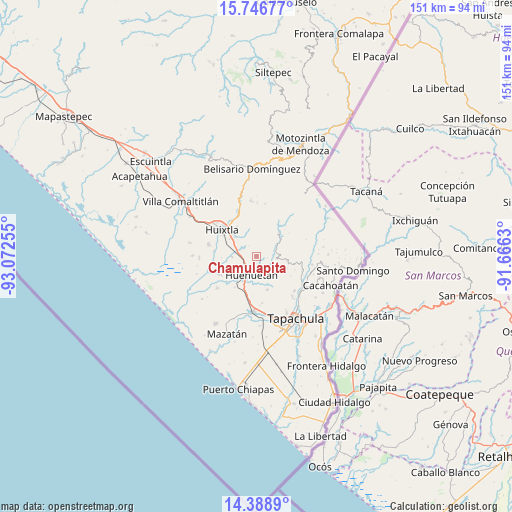
Chamulapita GPS coordinates[2]
15° 4' 8.112" North, 92° 22' 9.912" West
| Map corner | latitude | longitude |
|---|---|---|
| Upper-left | 15.74677°, | -93.07255° |
| Center: | 15.06892°, | -92.36942° |
| Lower-right: | 14.3889°, | -91.6663° |
| Map W x H: | 151×151 km | = 93.8×93.8mi |
| max Lat: | 32.7° ⇑99.3% North |
| Chamulapita: | 15.06892° |
| min Lat: | ⇓0.7% South 14.53588° |
| min Long | Chamulapita | max Long |
| -117.105° | -92.36942° | -86.73105° |
| W 93%⇐ | ⇒7% E |
Elevation
Elevation of Chamulapita is 111 m = 364 ft, and this is 1142.7 m = 3749 ft below average elevation for this country.
| Max E: |
3497 m = 11473 ft | 79% |
| Avg. | 1253.7 m = 4113 ft | |
| Chamulapita | 111 m = 364 ft | |
Min E: |
-1 m = -3 ft | 21% |
See also: Mexico elevation on elevation.city.
Geographical zone
Chamulapita is located in North Torrid zone (between Equator and Tropic of Cancer). Distance of this Northern Tropic circle is 930.4 km =578.1 mi to North.| Distance of | km | miles | from Chamulapita |
|---|---|---|---|
| North Pole | 8331.6 | 5177 | to North |
| Arctic Circle | 5725.7 | 3557.8 | to North |
| Tropic Cancer | 930.4 | 578.1 | to North |
| Equator | 1675.5 | 1041.1 | to South |


Nearby cities:
15 places around Chamulapita: (largest is in red/bold)
• Cantón Villaflor
5.4 km =3.4 mi,  19°
19°
• Cantón la Lima
8.5 km =5.3 mi,  235°
235°
• Chamulapa
4.1 km =2.5 mi,  245°
245°
• Cuarto Cantón
8.2 km =5.1 mi,  287°
287°
• Cuntalapa
5.6 km =3.5 mi,  212°
212°
• Cuyamiapa
6.4 km =4 mi, 236°
• El Chipilín
8.4 km =5.2 mi,  312°
312°
• El Edén
7.5 km =4.7 mi,  97°
97°
• Estación Huehuetán
7.6 km =4.7 mi, 211°
• Huehuetán
5.6 km =3.5 mi,  194°
194°
• Independencia
9.2 km =5.7 mi, 97°
• Primer Cantón
9.5 km =5.9 mi, 307°
• Segundo Cantón
7.9 km =4.9 mi,  296°
296°
• Villa Hidalgo
4.2 km =2.6 mi,  353°
353°
• Xochiltepec
9.5 km =5.9 mi, 313°
Sources, notices
• [Note1] Compared only with cities in Mexico existing in our database
• [Src1] Map data: © OpenStreetMap contributors (CC-BY-SA)
• [Src2] Other city data from geonames.org with taken over terms of usage.
• [Src3] Geographical zone / Annual Mean Temperature by Robert A. Rohde @ Wikipedia
